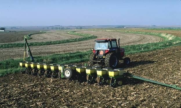
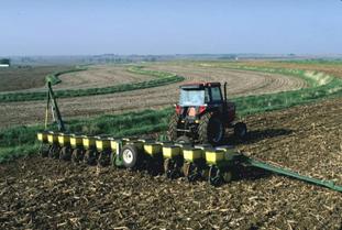
The fabric of Rushford's rural character is
intertwined within its abundant resources
3.1 AGRICULTURE,
CULTURAL & NATURAL RESOURCES
A. AGRICULTURAL
RESOURCES
The fabric of Rushford's rural character is
intertwined within its abundant resources
3.1 AGRICULTURE,
CULTURAL & NATURAL RESOURCES
A. AGRICULTURAL
RESOURCES
America's farmland is under ever increasing pressure from growth and development. Each year countless acres of rural land are moved into a developed state, calling into question at the national level our compatibility with sustainability. In partial response, the President has created "The President's Council on Sustainable Development". Between June 1993 and June 1999, the PCSD has advised President Clinton on sustainable development and develops bold, new approaches to achieve economic, environmental, and equity goals. We are committed to the achievement of a dignified, peaceful, and equitable existence. From this effort the United States Department of Agriculture (USDA), has committed its self to a number of new principals on sustainability.
"Guiding
Principles for Sustainable Development Policy
Following are the guiding principals established by the Department in support of USDA's sustainable development initiatives related to Sustainable Forestry, Sustainable Agriculture, and Sustainable Rural Community Development:
· Sustainable Agriculture -- USDA supports the economic, environmental, and social sustainability of diverse food, fiber, agriculture, forest, and range systems.
· Sustainable Forestry -- USDA balances the goals of improved production and profitability, stewardship of natural resources and ecological systems, and enhancement of the vitality of rural communities.
· Sustainable Rural Community Development -- USDA integrates these goals into its policies and programs, particularly through interagency collaboration, partnerships and outreach.[i]"
In 1997 USDA/NRCS (Natural Resource Conservation Service) estimated that throughout the Untied States there was approximately 330,556,300 acres of prime farmland.
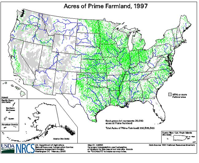
Predominantly focused in the upper Midwest, America's prime farmland regions coincide with our traditional notions of America's farm belt. While not containing as much prime farmland area as some other upper Midwest states, Wisconsin is still home to many acres of prime land. According to 1996 findings by the USDA/NRCS Wisconsin is home to 20,772 square miles or 13,294,027 acres of prime farmland. This area represents approximately 38% of the states entire area. Most of this land area can be found in the southern and eastern portion of the state. An additional concentration of prime farmland can also be found within Clark County and the western edge of Marathon County.
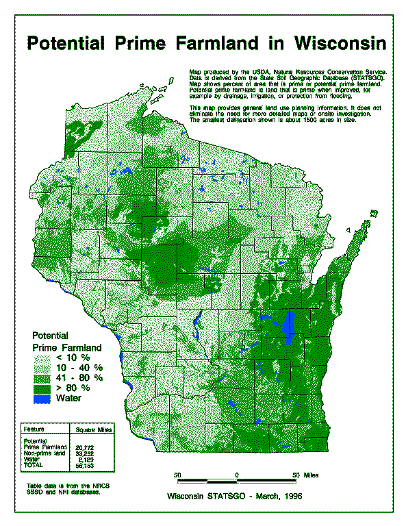
It should be noted that within Winnebago County high concentrations of prime farmland can be found throughout the county. Within this geographic area lies the Town of Rushford. As further development is considered, careful consideration of the lands potential productivity must be understood in order to protect this valuable community resource.
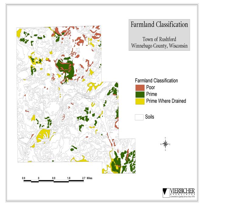
Within the Town of Rushford Prime Farmland, as defined by NRCS, is in limited supply. A widely used system of classification of soils primarily for agricultural purposes is called "land capability classification". This system is based on the most intensive longtime use for this land; site, surface and subsoil characteristics; soil limitations for safe use in crop production; and conservation practices for most intensive long time land use needed to correct limitations and/or potential soil management problems, serve as classification criteria. In this classification system, soils are grouped according to their potentialities and limitations (if any) for sustained production of common crops. This classification system places all soils into eight capability classes. The risk of soil damage or limitations in use becomes greater in progressing from Class I through class VIII. Soils in Classes I, II, III and IV, with good soils conservation management, are suited for pasture, woodland, and wildlife. Soils in Class VIII generally are non-productive for agricultural purposes and are recommended for wildlife habitat.
|
Capability Classification by Acreage - Town of Rushford, Winnebago County, Wisconsin |
||
|
|
|
|
|
Capability Classification |
Total Acres |
% |
|
Prime |
67,800 |
67.17% |
|
Prime Where Drained |
22,050 |
21.84% |
|
Poor |
11,090 |
10.99% |
|
|
|
|
|
TOTAL |
100,940 |
100% |
A visual representation of the distribution of Prime Farmland in the Town of Rushford can be reviewed on the following page.
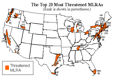
America's farmland is truly under an increasing threat. This is especially true
when considering the findings of a recently completed "Farming on the edge[ii]"
study completed for the American Farmland Trust. In this study the top 20 most
threatened Major Land Resource Areas (MLRA's) where identified. Specific to the
Town of Rushford is its geographic location within the third most threatened
area. While not currently deemed to be in a "High Quality & High
Development" location, it is readily apparent that the Town is on the cusp
of inclusion should the current pattern of growth continue.
"3. Southern
Wisconsin and Northern Illinois Drift Plain
(parts of Illinois and Wisconsin)
[MLRA no. 95B] More than 80 percent of the 11,020 square miles in this MLRA are
in farms. Feed grains and forage for livestock are the chief crops but
cash-grain farming (corn and soybeans) is also significant. Canning crops,
potatoes, fruit and other specialty crops are important, especially around the
urban areas in the south and east. On our map, 67 percent of this MLRA is red.
Because the suburbs of Milwaukee-Racine, Janesville-Beloit, Madison, Rockford
and Chicago are expanding rapidly and half the soils in this MLRA are prime or
unique, some of the best farmland in this MLRA is being used for urban
development. About 15 percent of the land is now urbanized. Our analysis
concluded that 59 percent of development was occurring on prime or unique
soils. The fastest growing county in the MLRA is McHenry County, Ill., just
north of Chicago. Between 1980 and 1992, the county's population grew by 35
percent. Other rapidly growing counties are Boone County near Rockford, Ill.,
Dane County where Madison, Wis. is located and Waukesha, Washington and Ozaukee
counties bordering Milwaukee."
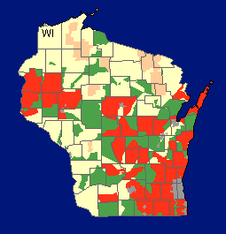
|
This
map portrays high quality farmland in each state by highlighting sub-county
geographic areas that meet two threshold tests that define the importance and
vulnerability of the land they encompass: High Quality Farmland includes areas that in
1992 had relatively large amounts (greater than their respective statewide
averages) of prime or unique farmland. High Development
includes areas that experienced relatively rapid development (greater than
their respective statewide averages and having at least 1,000 acres of urban
conversion) between 1982 and 1992. Other includes all areas
not meeting the two threshold tests. Unique
farmland was defined to include areas where unique soil and
climate conditions support the growth of specialty crops[iii]. |
![]()
At the State level, efforts to protect agricultural lands have been underway for many years. Principal among the many state programs aimed at farmland and agricultural protection is the granted authority to county's and local governments to adopt Exclusive Agricultural Zoning Ordinances. According to the Wisconsin Department of Agriculture, Trade & Consumer Protection the authority to create Exclusive Agriculture Districts has been granted to accomplish the following.
"Exclusive Agricultural Zoning Ordinances
The legislature has determined that local units of government, through the exercise of their zoning power, can best prevent conflicts between agricultural and nonagricultural land uses. A local government, by establishing an exclusive agricultural use district, effectively decides that agricultural uses of land are appropriate in that district. An exclusive agricultural zoning ordinance can be adopted by any county, town or municipality in a county that has a certified agricultural preservation plan in effect.
Preserving Wisconsin’s valuable farmland is important to the Department of Agriculture, Trade and Consumer Protection. This program assists counties in creating county agricultural preservation plans, which lay the groundwork for towns, municipalities and the county to develop exclusive agriculture zoning districts. Farmers also can participate by signing an individual, long-term agreement. The farmland preservation program provides state income tax credits to farmers who meet the program’s requirements: to meet soil and water conservation standards, and to only use the land for agriculture."
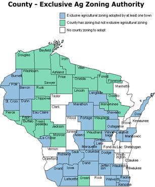
It can be noted that Winnebago County has been taking advantage of this protection tool with Exclusive Agricultural Zoning having been adopted by at least one town.
In Winnebago County, Wisconsin the 1997 U.S. Census of Agriculture reveled a number of interesting findings related to the growth and development of the Town of Rushford.
*
Land in
Farms - decreased 1% from 169,876 acres in 1992 to 167,459 acres in 1997.
*
Average Size
of Farms - Decreased 2% from 199 acres in 1992 to 195 acres in 1997.
* Full Time Farms - decreased 10% from 551 farms in 1992 to 498 farms in 1997.
While the number of acres and size of farms in the County and Town decreased only slightly, the actual number of full time farmers decreased at a significantly higher level.
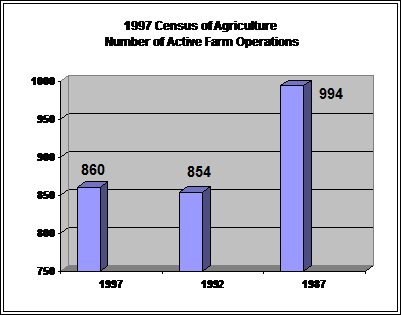
While the number of full time farms has decreased, the total number of farms seems to have leveled off. Currently, total farm numbers are holding at around 855 since 1992. This trend lends to speculation that remaining farms are buying up lands being vacated by farmers at a rate almost equal to that of the vacation. In addition, a slight gain in the number of smaller "hobby" farms seems to be holding the total number of farms at a stable level.
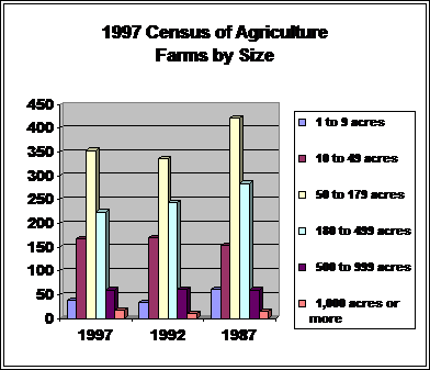
A closer investigation in the number and size of farms demonstrates that farm numbers, while holding stable in total number, have redistributed themselves in terms of mix. In 1982, the average farm operation in Winnebago County was 191 acres in size. In 1997, the average farm operation in Winnebago County covered 195 acres. This trend demonstrates a growth in the farms that are operating on 500 or more acres throughout the county. In 1987, there where fourteen farming operations covering 1,000 acres or more. In 1997, there are now 17 farming operations covering 1,000 acres or more. Operations from 500 to 1,000 acres in size have remained at 60 total over the period.
While the number of farming operations in Winnebago County is currently holding, the land values of the local farmsteads are increasing. In 1987 the average total farm value, land and buildings, was at $190,188. In 1997 the average value had grown to $331,110, an increase of 57% over the ten-year period.
"Agriculture remains the dominant land use in Winnebago County and is expected to maintain that role well into the 21st century while urban development in the form of residential, commercial, industrial, and highway expansion is expected to put unrelenting and growing pressures on the county’s natural resource base. The Fox River Valley is one of the fastest urbanizing areas in Wisconsin. In the past 10 years, approximately 10,000 acres of cropland, meadow, wetlands, and wooded areas have been converted to urban development in Winnebago County. These changes have often resulted in an increased impairment of natural resources due to the impacts associated with construction site erosion, increased volume of runoff, and polluted runoff. There are 154,000 people residing in Winnebago County in 1998. It is estimated that number will increase to 158,000 by 2010, a steady growth of about 3% in a 12 year period.
Land use planning to help control the type and direction of growth has been controversial, however, Winnebago County and it’s 16 civil townships continue to work on the development of comprehensive land use plans. Some of the common resource management concerns expressed throughout these planning efforts include:
4 preservation of farmland, open spaces, and wooded areas;
4 preservation of wetlands and similar wildlife habitat;
4 preservation of open vegetated drainage ways for filtration and stormwater management;
4 establishment of vegetated buffers along stream corridors to filter surface water; and
4 establishment of environmental corridors or ‘green belts’ between ecosystems.
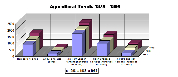
Since 1987 agriculture in Winnebago County has transitioned from predominantly dairy to predominantly cash grain production. The percentage of dairy sales in total cash receipts from farm markets has dropped from 60% in 1987 to about 45% in 1998. Conversely, cash grain receipts have risen sharply in the same time period. According to the 1978 through 1998 WDATCP Agricultural Statistics Reports, the following changes have impacted agriculture in the county during the past 20 years:
· there are 340 fewer farms (27% decrease );
· land in farms has decreased by approximately 29,000 acres (14% decrease);
· the size of farms has increased in average size from 161 acres to 197 acres (18% increase);
· cash cropped acreage from 115,000 acres to 96,900 acres (16% decrease);
· alfalfa and hay land decreased by 23,400 acres (48% decrease);
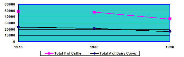
· total cattle (all cattle) numbers decreased by 11,900 (25% decrease); and
· total dairy cow numbers decreased by 7,500 (31% decrease).
Economic, political, and social factors will continue to impact farmland and related rural areas. It is expected that the number of farms in the county will steadily decline, while the size of the remaining farms will increase. Overall cattle numbers will decline as well however the size of the remaining herds is expected to increase substantially. These changes pose a challenge to all the stakeholders in terms of the planning for and sustaining of agricultural economic stability, diversifying farming operations, and protecting the natural resources.
Cattle Number
Trends in Winnebago County 1978-1998
It should also be noted that there is a growing trend of active farmland being converted to permanent grassland cover, wooded acreage, and wetland area through restoration projects. This is a positive trend from the standpoint of providing increased erosion control, water quality improvements, and wildlife habitat and it is expected to continue. Various USDA, state, and county programs have assisted landowners in planning for and implementing conservation practices on their lands. It is important that these programs and activities continue[iv]".
![]()
With the Town of Rushford's strong agricultural heritage it appears that agriculture will continue to play a role in the community, only in a new fashion. If the current trends are allowed to continue unchecked, questions on the development patterns of agricultural lands in the township arise. Specifically, what are the town's opinions towards an increasing number of larger "corporate" farms and is a landscape comprised of larger "corporate" farms mixed with scattered single family residences an acceptable development pattern?
A 1997 Citizen's Survey for Land Use Planning[v], found "in general, respondent's noted most often that they believed farmland/prime agricultural land, wildlife areas, land along creeks and rivers, and wetlands should be protected from development". 74% of survey respondents felt that the preservation of farmland and avoidance of conflict between agricultural and residential uses was very important, with another 19% feeling that it was somewhat important. These findings indicate broad community support for the protection and preservation of productive farmland areas within the town.
Between October of 1998, and October of 1999, the Town of Rushford created a Land Use Planning Committee. Working with the Winnebago County UW-Extension office, this committee undertook a yearlong educational and visioning process to further clarify what the town wanted to become. Within this exercise, committee members generated a statement of core values, a vision statement and a series of 16 planning goals.
Specific to the future of agricultural within the Town of Rushford, the "Town of Rushford Core Values Statement, identifies that the community "Values … farming and small business[vi]". Within the "Town of Rushford Vision Statement", the town sites that "We will achieve … Open space preservation, We will achieve … Supporting farming and agriculture, and We will achieve … Natural resource preservation, … through the successful implementation of an effective land use plan that balances community and private property rights[vii]".
From these core values and vision statement desires, the Town of Rushford Comprehensive Land Use Planning committee went on to further identify planning goals related to agriculture. "Goal #9 states, "Preserve a critical mass of productive farmland through equitable growth management policies (i.e., preserve land and land owner rights)". Goal #10 states, "Encourage the revitalization and preservation of diverse agricultural activity through the protection of highly farmable areas by focussing environmental preservation and residential development to areas less important to farming[viii]".
Clearly from these statements and goals it can be said that the Town of Rushford wants to maintain and enhance its agricultural character and base. In doing so, the town hopes to additionally preserve a key physical and aesthetic element, which contributes to the local sense of place, economy and rural character. The town wishes to comply with S. 16.965(4), Wis. Stats.: Goal #4 - “Protection of economically productive areas, including farmland & forests.”
Regional Landscape Ecosystems of Michigan,
Minnesota, and Wisconsin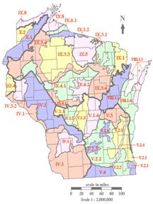
SUBSECTION V.3. Lake Winnebago Clay Plain
Clay lake plain and ground moraine; sugar
maple-basswood forest.
![]()
DISCUSSION: Subsection is an extension of the more expansive lake plain north of the tension zone in Subsection VIII.1, but much of the flat to undulating landscape is also ground moraine that has been reworked by proglacial lake waters (Lineback et al. 1983, Farrand et al. 1984). Unlike Subsection VIII.1, its silty soils are Alfisols rather than Spodosols.
SUB-SUBSECTIONS: None.
ELEVATION: 748 to 1,070 feet (228 to 326 m).
AREA: 1,165 square miles (3,018 sq km).
STATES: Wisconsin.
CLIMATE: Growing season ranges from 143
to 150 days (Wisconsin Agricultural Statistics Service 1987). Average annual
precipitation is 30 to 32 inches, and average annual snowfall ranges from 40
inches in the south to approximately 48 inches in the north (Wendland et al.
1992). Extreme minimum temperature ranges from approximately -30½F along Lake
Michigan to -35½F farther inland (Reinke et al. 1993).
BEDROCK GEOLOGY: Subsection is
underlain by Ordovician dolomite, with some limestone and shale (Ostrom 1981).
Depth to bedrock ranges from less than 50 feet to 200 feet (Trotta and Cotter
1973).
LANDFORMS: Flat till plain and lake
plain are prevalent. Much of the till plain has been reworked by proglacial
lake waters.
SOILS: Soils are red clays, containing
parent material both from local dolomite and reworked, northern lacustrine
deposits. Portions of the red, clay soils are derived from iron formations in
the Precambrian bedrock farther to the north (Hole 1976). Soils are more
carbonate rich than those farther to the north because of the underlying
dolomite of the subsection. Tills low in pebbles and cobbles have been mistaken
for lacustrine deposits in the area north and west of Lake Winnebago. The most
common soil of the subsection is silty clay loam to clay loam in texture. It
has almost equal parts of sand, silt, and clay; gravel, primarily dolomite,
makes up 10 to 20 percent of the coarse fraction. Soils are classified as
Alfisols.
PRESETTLEMENT VEGETATION: Sugar
maple-basswood forest covered most of the landscape; bur oak openings were
present in the southwest, where fire probably originated farther to the
southwest on the ground moraine of Sub-subsections V.2.2 or V.2.3 (Finley
1976). These oak openings extended to the north of Lake Winneconne and Lake
Butte des Morts on rolling ground moraine, and they may have persisted
partially as a result of Native American land management with fire. There were
Mosouakie villages and later Winnebago villages along Lakes Winnebago,
Winneconne, and Butte des Morts, and along the Fox River from before 1600 to
1830 (Tanner 1986). These lakes were along the major trade route from the
Wisconsin River, with a portage connecting to the Fox River and Green Bay.
Swamp forest grew in the wet depressions of the ground moraine. Two large
wetland areas consisted of wet meadow, wet prairie, and lowland shrubs (Finley
1976), one surrounding Lake Poygan and the other along the Fox River. East of
Lake Winnebago, along the North Branch of the Manitowoc River, there was also a
large area of lowland hardwoods.
NATURAL DISTURBANCE: Fire was probably
important at the southern edge. Large windthrows were noted within the northern
part (Cottam and Loucks 1984).
![]()
Winnebago County, established in 1840, is situated in east central Wisconsin. It is bordered on the east by, and includes, part of Lake Winnebago. It covers about 578 square miles with an actual land area of about 447 sq. miles. There are over 84,000 acres of surface water, the largest area of inland surface water of any county in Wisconsin. The majority of population and industry is located along the eastern side of the county with a large urban and industrial corridor running north to south along the west shore of Lake Winnebago. Comparative census figures show the number of County residents at 132,000 in1978 and 154,000 in1998. The population is concentrated in the cities of Menasha, Neenah, Omro, Oshkosh (county seat), the village of Winneconne, and two urban townships, Algoma and Menasha. The county has 16 civil townships and most of them have predominant rural/agricultural characteristics. Cash grain farming and dairying are the main agricultural activities and paper manufacturing is the principal industrial activity of the county.
For centuries, prior to the European settlement, the area that is now Winnebago County was inhabited by several thousand Native American Indians. These people were of the Menominee, Winnebago, Mascoutin, Miami, Potawatomi, Sac, and Fox tribes. They shared a sacred regard for the land and its resources and pursued a nomadic life of hunting, fishing, and rudimentary agriculture. The lakes, rivers, and adjacent marshes provided abundant supplies of fish, waterfowl, and other wildlife species. The name “Winnebago” evolved from the word “oninipegou”, meaning “Big fish people”. It was an appropriate name in view of the abundant sturgeon population found in Lake Winnebago at the time. This vast food source was still evident in the early 1800s when the wife of a local Indian Agent noted during her trip from Green Bay to Fort Winnebago at Portage:
“The river was filled with canoes, paddled principally by squaws. Many Indians were to be seen on the banks, all with their guns and hunting accoutrements, for the air was filled in every direction with flocks of teal . . . The immense fields of wild rice abounding here in the little lake (Little Lake Butte des Morts) below . . . We were hemmed in by a little fleet of canoes . . . the women chattering . . . putting forward their little wooden bowls of fresh cranberries . . .” (Prairie, Pines, and People - Winnebago County in a New Perspective, Ed. – James I. Metz, Oshkosh, WI 1978)
The area’s waterways provided an ideal transportation system for the tribes. The same system would eventually lead to the demise of their ancient cultures as the influx of French traders, missionaries, fur traders, and then American settlers increased.
The entire history and development of the county is centered around its water resources. The natural river connection between Green Bay and the Winnebago System provided access to the interior of Wisconsin. The first European settlers arrived around 1730.
By 1840 farming had a foothold and trading posts were
established at Butte des Morts, Omro, Oshkosh, and Winneconne and the first sawmill
was operating at Neenah. Between 1844 and the early 1900’s steamboats were
operating on Lake Winnebago, the upper Pool Lakes, and the Fox and Wolf Rivers
hauling freight, farm produce, and passengers. By 1850 wheat was the great
pioneer crop and by 1870 Neenah had 15 flourmills in operation. As lumbering
increased in the north woods more sawmills were built in Menasha, Neenah, and
Oshkosh. In time, Oshkosh, became one of the largest
and most prosperous lumbering towns in Wisconsin with over 45 sawmills. By the
late 1800s wheat production gave way to dairying as the dominant farming
activity in the county and the great lumbering era had peaked. The cities of
Menasha and Neenah had several paper mills operating and Oshkosh became a
manufacturing center for a variety of wood products.
Dams dating back to the 1850’s were built across the 2
river outlets of Lake Winnebago at Neenah and Menasha. The dams were originally
constructed to manage water levels for commercial navigation and waterpower
generation. The water level of Lake Winnebago and the upriver lakes were raised
2 to 3 feet to form the ‘Winnebago Pool’.
In the late 1800s an act of Congress gave the U.S. Army Corps of
Engineers the responsibility of managing water levels for the upstream
‘Pool’. The Corps is still in charge of
water level management for the System.
To fully understand the importance of natural resources to Winnebago County and the surrounding region, it is essential to recognize that, in addition to the countless environmental benefits they provide, those resources bring in tens of millions of dollars in revenue to local communities throughout the county each year. That revenue comes primarily from the vast array of recreational users of the resources. While it is difficult to place a specific dollar value on these resources, straight-line logic tells us that we absolutely cannot afford to waste them and must do all that we can to protect them – for present and future generations.
The entire landscape of Winnebago County reflects the influences of glacial activity. The most recent glacier to cover the county occurred about 10,000 years ago. It covered all but the southwestern part of the county and deposited the reddish clayey till we see today. Southwestern Winnebago County was covered by older glacial activity that deposited brownish, loamy till.
The topography is nearly level or gently rolling with slopes of 6% or less over 90% of the terrain. Two escarpments run northeasterly across the county ranging from 750 to about 950 ft. above sea level owing to land relief on the order of about 200 feet. The most prominent features are the broad expanses of lakes and adjacent marshes. Topographic features are controlled by the subsurface geology which is mainly sandstone and limestone positioned equally throughout the western and eastern parts of the county. A varying thickness of glacial till overlies the irregular surface of these rock formations. The glacial material over the limestone formation is, however, much thinner than the material over the sandstone.
The county is entirely within the Fox-Wolf River Basin and contains 84,000 acres of surface water. Its network of lakes, rivers, and streams make up the major portion of what is known as the ‘Winnebago System’. The System includes the ‘Pool’ Lakes of Winnebago, Butte des Morts, Winneconne, and Poygan along with the main tributary waters of the Upper Fox and Wolf Rivers.
The Fox River enters Winnebago County near Eureka, flows northeasterly through Lake Butte des Morts and Lake Winnebago, flows over the dams at Neenah and Menasha, and continues down through Little Lake Butte des Morts. It outlets into Green Bay 39 miles downstream from Lake Winnebago after it follows a meandering course with a vertical drop of 168 feet. Lake Winnebago divides the Fox River into the Upper and Lower Fox.
The Wolf River enters the county in the northwestern corner, flows southeasterly through Lakes Poygan and Winneconne, and then converges with the Fox River at the west end of Lake Butte des Morts. Of the total inflow to the Winnebago Pool from the Fox and Wolf Rivers combined, the Wolf River accounts for approximately 60%.
Two lakes in the County that are not located in the Pool are Rush Lake and Little Lake Butte des Morts. Rush Lake is a natural and unique prairie pothole about 3,000 acres in size and is situated in the southwest corner of the county. It contains large bog areas and lake adjacent wetlands and receives direct runoff from much of the surrounding agricultural watershed through streams and man made drainage ditches. It flows out to the Fox River by way of Rush/Waukau Creek and it is used for hunting, fishing, trapping, and canoeing. Little Lake Butte des Morts, about 1,300 acres in size, is situated in the northeast part of the county immediately downstream from the dams at Neenah and Menasha. The 15,000 acre Neenah Slough Watershed also outlets into the south end of the lake downstream from the dam at Neenah. The lake receives additional runoff from a mixed agricultural and urban watershed to the west. Primary uses of the lake include boating, fishing, and hunting. It is impacted by point and nonpoint source pollution and it contains beds of PCB contaminated sediments that are included in remediation planning efforts between industries, the WDNR, and the USEPA.
The Winnebago System is one of Wisconsin’s most
significant water resources, representing 17% of the State’s total surface
water acreage. It is located within 75 miles of over 2 million people and
receives heavy recreational use for fishing, boating, swimming, hunting, and
trapping. In addition, aquatic plants, such as wild celery and sago pondweed
tubers, are harvested commercially along with an active commercial setline
fishery for catfish. Lake Winnebago alone provides drinking water to over
100,000 people in the cities of Oshkosh, Neenah, and Menasha.
Before the dams at Neenah and Menasha were constructed, the System supported massive areas of emergent and submergent rooted aquatic plants. Lake Winnebago contained great numbers of bays and marshes. Lakes Butte des Morts, Winneconne, and Poygan were characterized as river marshes. Through the decades, high water levels combined with erosive action from wind, wave, and ice have lead to the destruction of tens of thousands of acres of wetland habitat within the Pool. This has resulted in the loss of natural filtration capabilities that once served to trap sediments and nutrients. Shoreline and streambank erosion is a continuing problem in most areas of the System where wetlands once flourished and helped to buffer erosive forces. Left unprotected the problems only worsen.
Given the natural characteristics of the Winnebago System, it is likely that the waters were always fertile, however, they are now described as being highly eutrophic. This is the direct result of impacts from nonpoint pollution. Excessive nutrient and sediment delivery into the System from agricultural and urban sources contribute towards massive algae blooms that occur with increasing frequency. The algae and sediments increase turbidity, hinder growth of beneficial aquatic plants, and deplete important fish spawning areas.
“These alterations and the resulting loss of wetland habitat have directly affected the abundance and diversity of fish and wildlife. In particular, there have been substantial reductions in duck use, especially canvasbacks, during spring and fall migrations. . . . present habitat favors open water fish such as sheepshead and gizzard shad, while species such as northern pike, bass, yellow perch and other panfish have experienced declines… Given the amount of use received by the resources . . . intensive management is needed to maintain and improve a variety of beneficial public use opportunities. Past efforts to manage the system have been hampered by the sheer size of the watershed, the complexity of ecological and use-related factors that drive the System’s management and conflicting interests among various users. . . . For these reasons the Winnebago Comprehensive Management Project was initiated to develop and implement a long-range plan that would fully integrate DNR programs with those of other agencies, and especially with the various interests of the System’s resource users.” (Winnebago Comprehensive Management Plan, R. Bruch-WDNR, 1989)
General
Watershed Characteristics
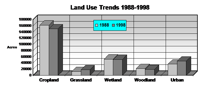
At approximately 125 square miles in size, the Fox River/Rush Lake Watershed is easily the largest in the county. Within this watershed the communities of Omro, Waukau, Eureka, Pickett, and Rush Lake can be found. Land use is primarily agricultural in nature with small dairy operations and cash grain farms as the primary means. The Rush Lake/Waukau Creek Watershed was listed as a Non-Point Source Priority area in the Lake Winnebago Comprehensive Management Plan of 1989. This was based on high critical soil erosion rates in excess of 5.2 ton/acre/year. Eightmile creek, a major tributary to Waukau Creek has rates exceeding 4.1 tons/acre/year.
|
Land Use |
Percent |
|
|
Cropland |
42,150 |
52.5% |
|
Non-metallic Mining |
170 |
0.2% |
|
Grassland/Pasture |
5,670 |
7.1% |
|
Urban/Developed |
3,990 |
5.0% |
|
Wetlands |
22,210 |
27.7% |
|
Woodland |
3,670 |
4.6% |
|
Watershed Totals |
80,240 |
100% |
Land
& Water Resource Assessment
The Fox River Watershed covers approximately 20.6 square miles of Winnebago County. The primary land-use of this area is agricultural, being split between small dairies and cash grain farms. There are also extensive areas of wetland within the watershed, primarily in the flood plain of the river. Many of these wetlands are crucial spawning areas for walleye and northern pike.
The nonpoint sources of pollution in this watershed are
agriculturally related, with upland erosion being the primary source of
sediment. Average soil erosion rates for
the watershed are in excess of 3 tons/acre/year. There are also several animal lots that
annually contribute nutrients to runoff.
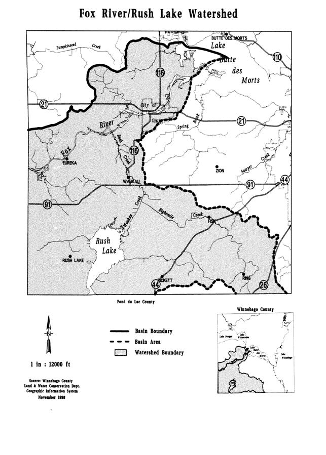
Rush Lake
Rush lake, a large (3,070 acres), shallow (5 feet), marshy basin, is subject to yearly winter fish kills. Many fish species rely on the lake as a spawning ground. It is also a major wildlife area that serves as a resting point and a breeding area for many migratory waterfowl. One main problem in the lake is due to the amount of lead shot in bottom sediments. Waterfowl deaths have occurred due to lead shot poisoning. Excessive nutrient levels is another main problem in Rush Lake. In the past, the Rush Lake fishery has been opened to dip netting during periods of dissolved oxygen depletion.
The average critical soil erosion rate in the Rush Lake drainage area is in excess of 3 T/A/YR. Although vast wetland areas surround the lake, pollutants have direct access through a series of old drainage ditches that drain large, historic wetland areas. If this area is selected in the future this problem should be addressed through a nonpoint source pollution project.
Waukau Creek is a tributary to the Fox River and also drains
Rush Lake. This stream has a very low
rate of flow and may dry up during drought periods. Silt, gravel, and rubble are the major bottom
materials. Northern pike, walleye, and
carp migrate up the creek to Rush Lake in the spring to spawn. Average soil loss in the Waukau
Creek/Eightmile Creek drainage area is in excess of 5.2 tons/acre/year. In addition to a high sediment delivery rate,
runoff from animal lots is also a significant problem within the watershed.
General
Watershed Characteristics
The Pine River and Willow Creek Watershed covers approximately 308 square miles, 49.3 of which are located in Winnebago County. Most of the watershed lies within Waushara County with a very small portion in Waupaca County. The west half of the village of Winneconne is the only incorporated community in Winnebago County in the watershed.
The Pine River and Willow Creek Watershed was selected as a priority watershed in 1995 and entered the planning phase in 1996. An extensive inventory was performed watershed wide to determine the extent of impairment to the watershed due to non-point sources of pollution. The inventory results were used to set pollution reduction goals and eligibility criteria for the program. The watershed plan was approved by the Land and Water Conservation Board in December 1997 and received authority to begin signing cost-share agreements for the implementation phase in July of 1998.
Stream habitat in the western half of the watershed is generally in good condition. Streambank erosion and cattle access appears to be minimal. Bank vegetative cover is generally good with diverse trees, shrubs, and grasses. Habitat in the eastern half of the watershed is generally fair to poor. Many of the tributaries, especially those with direct drainage to Lake Poygan, have been ditched and straightened to quickly convey water off the land and dry the soil. Eliminating the natural meandering destroys pools and increases stream velocity. High stream velocities increase erosion and suspended solids concentrations and prevents the reproduction of some fish species.
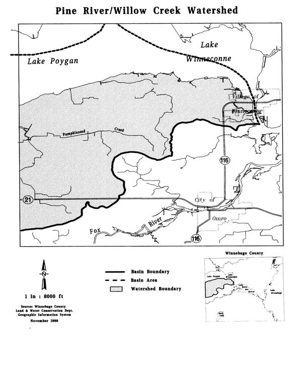
Farming is of vital importance to this area as agriculture
comprises nearly 65% of the overall land use in the watershed with the average
farm size encompassing approximately 214 acres.
Dairy farming is the predominant land use at the present time, although
cash grain farming is increasing with corn, and soybeans being the principal
crops grown.
|
Land Use |
Percent |
|
|
Cropland |
13,520 |
42.9% |
|
Non-metallic Mining |
45 |
0.1% |
|
Grassland/Pasture |
1,080 |
3.4% |
|
Urban/Developed |
1,410 |
4.5% |
|
Wetlands |
4,760 |
15.1% |
|
Woodland |
2,030 |
6.4% |
|
Watershed Totals |
31,535 |
100% |
The Pine River is a 28-mile tributary to the northwest corner of Lake Poygan. The river is divided into the Upper Pine (above the Wild Rose Millpond) and the Lower Pine.
Though the entire river lies within Waushara County, it impacts the water of Winnebago County by discharging into Lake Poygan. Sediment and nutrient loading are a concern in the lower stretches of the Pine as the river flows through an intensively farmed area before it enters the lake.
Willow Creek is a 43-mile long tributary to the southwest corner of Lake Poygan and is entirely within Waushara County. The upper reaches of the Creek are in very good condition as this stretch is flows primarily through wooded areas. As the Creek flows further east, land-use begins to switch and become more intensively farmed and water quality begins to decline. Sediment and nutrient delivery from intensive row cropping is one of the main sources.
The Mount Morris Dam, which was under repair, gave way in August 1995 after heavy rains. Two bridges southeast of the earthen, 100-year-old structure washed out soon after it burst. Water from five impoundments poured through the ruptured dam and swept tons of sediment down Willow Creek and into marshes and further into Lake Poygan, endangering fish spawning and rearing areas.
Pumpkinseed Creek originates in wetland areas and ditches south of Lake Poygan and eventually empties into Lake Poygan. Lake Poygan’s water quality and water levels influence the lower three miles. The upper reaches receive runoff from agricultural fields and drainage ditches.
The ditched and straightened creek has little rubble substrate or other desirable habitat. Huge sediment bars cover the bottom, filamentous algae growth is abundant and the banks have little vegetative buffer to protect from upland crop erosion. The banks flood easily with runoff events. Boat activity on the lower reaches of the creek causes bank erosion problems.
Aquatic life is most significantly limited by the lack of
available habitat and intermittent stream flow of Pumpkinseed Creek and its
tributaries. The channelized creek
speeds runoff rates and only supplies adequate aquatic life habitat during
snowmelt and rain events. Little
vegetative buffers along with sediment accumulation, dense algae growth caused
by nutrient inputs, and motor boat activity are other factors limiting aquatic
life in this subwatershed. A sediment
and nutrient loading reduction would not only benefit Lake Poygan, but also
provide better habitat in the streams when water is available.
Despite the losses of
aquatic habitat within the Winnebago System, it continues to be known
throughout the Midwest for its excellent walleye and white bass populations, as
well as it’s world class population of lake
sturgeon.
The lower 125 miles of
the Wolf River and 37 miles of the upper Fox River contain the spawning and
nursery grounds for the Winnebago Pool sturgeon and walleye populations. In addition to lake sturgeon, walleye and
white bass, the major species of the Winnebago Pool fisheries community include
freshwater drum, sauger, yellow perch, largemouth and smallmouth bass, panfish,
trout perch, and emerald shiner. Seventy-eight species of fish are found within
the Winnebago Pool Lakes. The recreational fishing opportunities supported by
this diverse fishery provide for over one million angler hours annually. That
equates to tens of millions of dollars being pumped back into the local economy
each year.
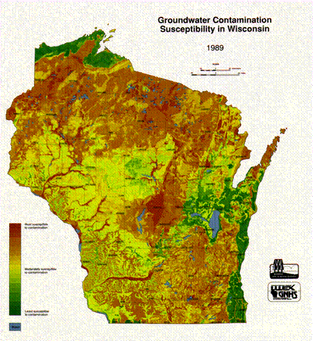
Groundwater resources in Winnebago County are, for the most part, of very good quality and in plentiful supply. There are three aquifers that supply potable groundwater. The sandstone aquifer is the most extensive and the only one of the three that can sustain high capacity pumping wells for municipal and industrial uses. The Platteville-Decorah-Galena aquifer is composed primarily of dolomite which is present in the eastern third of the County and provides adequate private water sources. Local problems in this aquifer include high sulfate and iron concentrations along with hardness that results from the geochemistry of the dolomite formation. The water table aquifer is composed of varying thicknesses of glacial sediments, primarily sand and gravel, whose seams transmit adequate amounts of water for private wells.
All of the groundwater in the county originates from
local precipitation that infiltrates through the soil into recharge areas of
the aquifers. Contamination risks from land use practices are the greatest
threat to groundwater resources. The potential sources of contaminants are from
old unregulated landfills, underground storage tanks, on-site waste disposal
systems, livestock manure handling and storage, and septic disposal. All of
these sources are presently regulated or are being addressed through ordinances
and/or technical assistance services by various county and state agencies.
Future availability of potable water is also a concern that is receiving attention. For the present time, based on volume of demand from agricultural, industrial, and residential uses, those concerns center on the Fox Cities, from northeastern Winnebago County, downstream to Green Bay. A U.S.G.S Fox Cities Water Study was recently completed. It indicates that existing potable water supplies will be adequate to meet projected demand through 2050. However, water treatment costs may be higher for communities that depend on groundwater due to a significant lowering of the prime use aquifer. Other conservation and protection options that are being considered include regulatory mechanisms and development of a groundwater withdrawal management program.
Approximately 51,400 acres of wetland still exist in
Winnebago County. This is less than half of the total wetland acreage that
existed in the county prior to the late 1800’s. Most of the wetlands are
located in the western and northern parts of the county. The largest areas are
associated with Lake Poygan, Rush Lake, Rush/Waukau Creek, and the Fox, Rat,
and Wolf Rivers.
As the result of high water levels along with draining and filling in the System, the greatest and most rapid loss of wetlands has occurred during the past 75 years, although, there were extensive areas of wetlands that were lost during the late 1800’s and early 1900’s. The primary causes for wetland destruction in the county have been seasonably high lake levels coupled with accelerated agricultural drainage and filling for urban development. This has resulted in degraded water quality, loss of natural filtration and storage areas, increased localized flooding, and loss of important fish and wildlife habitat.
There are three wetland habitat types found in Winnebago County, the Emergent Wetland, the Scrub-shrub Wetland, and the Forested Wetland. Each of these represents a unique ecosystem based on hydrologic conditions, vegetation, and location in relationship to other wetlands, drier upland areas, or adjacent water bodies.
In addition to providing habitat for fish, waterfowl, and other wildlife species, the remaining wetlands are important for the recharge of aquifers and the protection of groundwater quality. They are extremely efficient at trapping and filtering out nutrients and sediments contained in runoff and they provide highly effective flood storage areas. It is critical that the remaining wetland resources in Winnebago County be protected from further destruction. Existing county, state, and federal regulatory protection mechanisms need to be integrated and enforced to a greater extent than they are now. In addition, for the protection of wetlands adjacent to lakes and rivers, technical and financial resources for streambank and shoreline erosion control measures need to be expanded.
The lakes, marshes, rivers, and adjacent uplands in
Winnebago County have provided prime waterfowl habitat for centuries. Sharp
declines in duck populations throughout the U.S. during the 1970’s and 80’s
reflected the dramatic use of the Winnebago System by ducks and coincided with
the loss of important aquatic food sources, such as wild celery. In recent years, DNR staff and local sporting
clubs have been working cooperatively to restore wild celery beds in Lake
Poygan – once known as the ‘Canavasback Capital of the World’. Duck populations
are currently on the increase and waterfowl hunting, as always, remains an
important recreational activity in the county. Other important hunting activities
in the county include bow and gun deer hunting and pheasant hunting. Wild
Turkeys have been restored to the western half of the county and are now
providing additional hunting opportunities.
Because Winnebago County is located in what was formerly one of the best regions of the state for duck and pheasant production, the Department of Natural Resources initiated the Glacial Habitat Restoration Area project in the southwestern part of the county. This project is designed to restore wetlands and grasslands on private lands and public lands to benefit mallards, blue-winged teal, pheasants, and grassland songbirds.
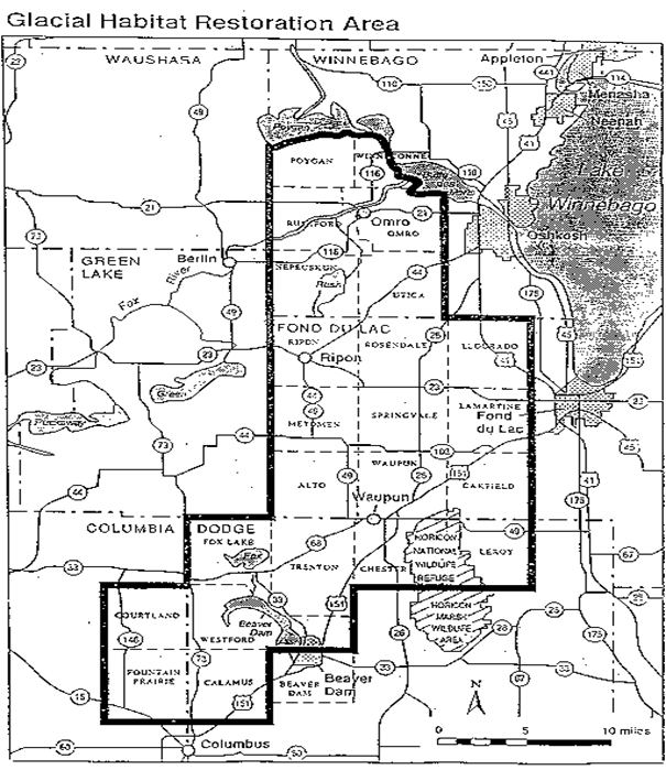
“The goals of the program are to restore 10% of available upland to permanent grassland, and to restore 10% of the drained wetlands. The department is purchasing land and perpetual conservation easements from landowners within the GHRA in order to meet habitat goals. Department ownership in any town will not exceed 10% of the total land.
The properties the DNR currently owns are managed primarily for grassland birds and other native wildlife. On properties the department manages, croplands are gradually converted to native prairie, and wetland drainages are disabled, creating a mix of wetlands and grasslands crucial to wildlife. An integral part of grassland management is prescribed burning. Grasslands evolved with fire and the department periodically burns (every 3-5 years) these properties to enhance and maintain the biological integrity of the land.
The fee-title properties are open to hunting, trapping, hiking and other non-motorized nature based recreation”.[ix]
Also with this part of the county, and the Town of Rushford, lies the Thull tract of the Uihlein Waterfowl Production Area administered by the U.S. Fish and Wildlife service’s National Wildlife Refuge System. In southeastern Wisconsin the Leopold Wetland Management District is responsible for management of the WPA’s.
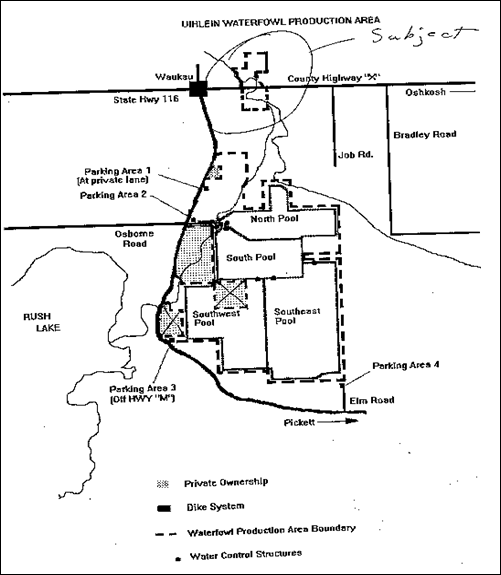
Long term goals for the Fish & Wildlife Service is to continue acquiring land from willing sellers as it becomes available to “round out” or join together the tracts already under ownership. Management objectives for the Thull tract of the Uihlein WPA are to:
1. Help assure the continued availability of habitat capable of supporting migratory bird populations at desired levels.
2. Demonstrate optimizing the practice of wildlife and wildlands management.
3. Expanding the understanding and appreciation of wildlife, wildlands ecology and man’s role in his environment.
4. Develop optimum levels of the kinds, range, amount and quality of wildlife and wildlands-oriented recreation desired.
5. Help assure the survival of a natural state of each of this areas plant and animal species.
6. Optimize the abundance and diversity of native wildlife on each WPA compatible with carrying capacity and other constraints.
7. Restore and maintain the native prairie/savanna portion of this tract through the use of management tools such as fire, cutting, herbicide treatment, etc. Possibility of removing and re-seeding non-local genotype nesting field adjacent to prairie/savanna remnant to ensure genetic integrity of native prairie and savanna remnant.
8. Maintain native seeded grass/forb fields through the use of fire.
9. Maintain seeded cool-season (CRP) fields to provide a diversity of habitats.
10. Improve the remaining oak savanna/hard wood stands through the use of fire.
11. Remove and treat Boxelder stands.
12. Maintain grassland buffer adjacent to Waukau creek for water quality improvement purposes.
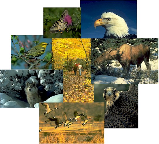
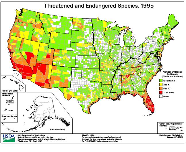
The county also has many special concern resources that require protection and recognition in planning and implementing land and water resource management. Many natural communities exist around the county that are associated with private and public lands and the waters of the county. These include various wetland, prairie, forest and oak-savanna communities. Two State Natural Areas have been designated in the county. Both of these are prairies associated with public recreational trails. Three species of endangered plants and three species of threatened plants have occurred in Winnebago County. Four endangered aquatic bird species have occurred in the county, three breed here annually. Other species of concern include two threatened fish, one endangered fish, one threatened mussel, and two threatened turtles that have been documented to occur in the county.
RARE, THREATENED AND
ENDANGERED SPECIES
AND NATURAL COMMUNITIES IN
WINNEBAGO COUNTY
|
PLANTS |
||
|
Common Name |
Species Name |
Wisconsin Status1 |
|
Poa paludigena |
Threatened* |
|
|
Aster furcatus |
Threatened* |
|
|
Indian Cucumber-Root |
Medeola virginiana |
Special Concern |
|
Kentucky Coffee-Tree |
Gymnocladus dioicus |
Special Concern |
|
Armoracia lacustris |
Endangered* |
|
|
Platanthera leucophaea |
Endangered** |
|
|
Asclepias purpurascens |
Endangered |
|
|
Cypripedium candidum |
Threatened |
|
|
Wax Meadowrue |
Thalictrum revolutum |
Special Concern |
|
ANIMALS |
|||
|
Common Name |
Species Name |
Wisconsin Status1 |
Taxa |
|
Black Tern |
Chlidonias niger |
Special Concern * |
Bird |
|
Black-Crowned Night-Heron |
Nycticorax nycticorax |
Special Concern |
Bird |
|
Sterna caspia |
Endangered |
Bird |
|
|
Common Moorhen |
Gallinula chloropus |
Special Concern |
Bird |
|
Sterna hirundo |
Endangered* |
Bird |
|
|
Sterna forsteri |
Endangered |
Bird |
|
|
Least Bittern |
Ixobrychus exilis |
Special Concern |
Bird |
|
Podiceps grisegena |
Endangered |
Bird |
|
|
Western Grebe |
Aechmophorus occidentalis |
Special Concern |
Bird |
|
Broad-Winged Skipper |
Poanes viator |
Special Concern |
Butterfly |
|
Gorgone Checker Spot |
Chlosyne gorgone carlota |
Special Concern |
Butterfly |
|
Mulberry Wing |
Poanes massasoit |
Special Concern |
Butterfly |
|
Banded Killifish |
Fundulus diaphanus |
Special Concern |
Fish |
|
Creek Chubsucker |
Erimyzon oblongus |
Special Concern |
Fish |
|
Moxostoma valenciennesi |
Threatened* |
Fish |
|
|
Lake Chubsucker |
Erimyzon sucetta |
Special Concern |
Fish |
|
Lake Sturgeon |
Acipenser fulvescens |
Special Concern * |
Fish |
|
Pugnose Minnow |
Opsopoeodus emiliae |
Special Concern |
Fish |
|
Notropis anogenus |
Threatened |
Fish |
|
|
Luxilus chrysocephalus |
Endangered |
Fish |
|
|
Tritogonia verrucosa |
Threatened |
Mussel |
|
|
Round Pigtoe |
Pleurobema sintoxia |
Special Concern |
Mussel |
|
Emydoidea blandingii |
Threatened* |
Turtle |
|
|
Clemmys insculpta |
Threatened |
Turtle |
|
|
Natural Communities |
||
|
Bird Rookery |
Northern Dry-Mesic Forest |
Southern Dry-Mesic Forest |
1Wisconsin Status:
Endangered: continued
existence in Wisconsin is in jeopardy.
Threatened: appears likely, within the foreseeable future, to
become endangered.
Special Concern: species for which some problem of abundance or distribution is
suspected but not yet proven.
Rule: protected or regulated by state or federal legislation or policy; neither
endangered nor threatened.
* indicates: A candidate for federal listing.
** indicates: Federally Endangered or Threatened.
Prior to settlement, the vegetation of Winnebago
County was mostly forest and oak savanna. Areas of sedge meadow and prairie
grass in the northern and western parts of the county covered the balance of
the land. Most of the forests were
cleared for agricultural crops and today roughly 20,000 acres are still in
woodland cover. The composition of species is: oak-hickory = 7,000 acres;
maple-beech-birch = 6,000 acres; ash-aspen-cottonwood = 5,000 acres; and mixed
conifers = 2,000 acres.
Although the woodland acreage of the county is
relatively small, it provides a considerable source of timber and related
products for private use. The woodlands are also very important in terms of
providing habitat for a variety of wildlife species. More importantly, from an agricultural
perspective, are the soil conservation benefits from wind and water erosion
reduction. Improved woodland management will be necessary in order to maintain
these benefits. Programs that promote tree planting and sustained management of
woodland resources help landowners accomplish this objective. These include the
federal Conservation Reserve Program and the Wisconsin Managed Forest Law
Program.
A disturbing trend affecting the woodland resources in the County comes from development pressures that result in fragmentation or outright destruction of wooded areas. Protection is needed through effective implementation of land use planning.
 Mineral
Resources
Mineral
ResourcesThe geologic and glacial history of the county is reflected in it’s mineral resources that provide a substantial volume of the total aggregate material used in construction activities throughout the county and surrounding region. Estimated acreage of those mineral resources that occur within 5 feet of the surface is: limestone = 5,500 acres; sand and gravel = 6,000 acres; and mason sand = 3,000 acres. These mineral resources are distributed more or less equally around the county. There are approximately 50 sand and gravel pits and about 30 rock quarries that are 3 acres or larger in area.
Some of the best quality limestone is found in Winnebago County. This material is an excellent source of rock riprap that is used extensively for shoreline and streambank protection throughout the Winnebago System. It should also be noted that a number of inactive pits and quarries have filled with water and provide unique fish and wildlife habitat.
It is important from an economical and environmental standpoint that these mineral resources be protected from encroaching development and contamination. Winnebago County’s town boards and private enterprises have taken a proactive approach in that direction through the development of applicable zoning ordinances that include restrictions on development and mineral extraction, as well requiring reclamation.
Individual soil types, with specific and unique characteristics, directly influence land uses. Soil type is the primary factor that affects the selection of the types and extent of agricultural practices and management techniques that may be used to sustain high productivity levels.
There are 74 different soil types found throughout Winnebago County. These are grouped into seven major soil associations that have distinctive soil patterns, relief, and drainage features. The Winnebago County Soil Survey contains detailed descriptions for each soil type, including information on suitability and limitations for various types of land use and land management. The Winnebago County Land & Water Conservation Department extensively uses the soils information and related data in determining cropland soil erosion estimates and sediment load calculation.
Understanding the Town of Rushford and Winnebago County's abundant natural resources allows for proper examination of any potential negative impacts proposed developments might have. While not defined in this Comprehensive Plan Element to specific geographic locations, field investigations at proposed new development locations may be called for in the review and approval process. Collaborative relationships with County staff and State Agency representatives will serve as valuable networks to ensure that these resources are protected and preserved within the Town of Rushford. By taking these actions the Town of Rushford will be achieving S. 16.965(4), Wis. Stats.: Goal #3 - “Protection of natural areas, including wetlands, wildlife habitats, lakes, woodlands, open spaces and groundwater resources.”
Rushford's family farm
culture is a valued source of community pride
C. 
CULTURAL
RESOURCES
The Town of Rushford is rich in its cultural heritage and current diversity. With founding ethnic origins of English and German decent, current ethnic background remains predominantly English and German. Located in the Wisconsin County known as “The Wave of the Future” the Town of Rushford boosts many unique attractions from its heritage base. The historic “The Day They Gave Babies Away” historical marker in Eureka stands in the countryside serving as an active reminder of generations past and the struggles they endured.
Currently there are 178 records of buildings throughout the
township registered 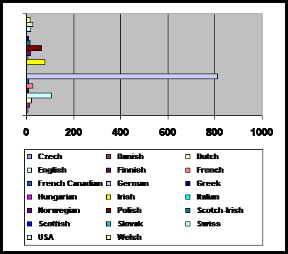 in the State
Historical
in the State
Historical
Society of Wisconsin's "Wisconsin Architecture & History Inventory" of historic buildings. The Architecture and History Inventory (AHI) is a collection of information on historic buildings, structures, sites, objects, and historic districts throughout the Wisconsin. This Inventory is housed at the State Historical Society of Wisconsin in Madison and is maintained by the Society's Division of Historic Preservation. The AHI is comprised of written text and photographs of each property, which document the property's architecture and history.
Most properties become part of the Inventory as a result of a systematic architectural and historical survey. From its beginning in the mid-1970s until 1980, reconnaissance surveys were conducted by summer students. Starting in 1980, intensive surveys were funded by subgrants and conducted by professional historic preservation consultants.
Old buildings have a special relevance to our lives today, bringing a “sense of place” to our lives and our communities.
They also tell the social, cultural, economic, and political history of people in a way that no printed word or photograph can. Thus, telling the story of Wisconsin’s historic architecture is a way of documenting the diverse experiences of Wisconsin people and places.
Just as the preservation and protection of Historic sites and buildings is important to the Town of Rushford so is the protection and preservation of archaeological sites. Confirmation of this can be found in the town’s vision statement “We value … our culture and historical background”.
|
Panther effigy mound surrounded |
Preservation
of Wisconsin
Archaeological Sites
It is estimated that nearly 80% of the archaeological sites that once existed in the state have been destroyed or severely damaged, primarily by modern land practices such as development and farming. Many sites have also been damaged by looting.
Laws and Statutes
Federal Projects
Section 106 of the National Historical Preservation Act of 1966, As
Amended requires federal agencies to insure that their actions (grants,
funding, permits, activities such as highway building, etc.) do not adversely
affect archaeological sites on or eligible for the National Register of Historic
Places.
State Projects
Archaeological sites can be protected during the course of state agency
activities (grants, funding, permits, ground disturbing projects) if the sites
have been recorded with the Office of the State Archaeologist. See Section 44.40
Wisconsin Statutes.
Political Subdivision
Projects
Archaeological may be protected during the course of
village, city, county and other political subdivision projects (e.g. building,
road construction, etc.) but only if the site is listed on the National
Register of Historic Places. See Section 44.43 Wisconsin Statutes
Burial Sites
All human burial sites, including cemeteries and
Indian mounds, are protected under state law Section 157.70 Wisconsin
Statutes. The laws applies to both public and
private lands. Owners of burial sites may receive property tax exemptions. The
law is administered by the SHSW Burial
Sites Program.
Rock Art Sites
Destruction and vandalism of ancient rock art sites
listed on the National Register of Historic Places
without landowner permission is a felony under Section 943.01 Wisconsin
Statutes.
Public Lands
Federal Lands: It is illegal to remove
artifacts or otherwise disturbed archaeological sites on federal lands without
a permit under the Archaeological Resource Protection Act of 1979. Federal
lands in Wisconsin include National Forests, National Parks, and federal trust
lands such as Indian Reservations.
State Lands: It
is illegal to remove artifacts or otherwise disturb archaeological sites on
state or or political subdivision (village, city, county )
lands without a permit under The Field Archaeology Act Section 44.47
Wisconsin Statutes. The law applies to both archaeological sites on
public lands and submerged sites such as Shipwrecks on publicly owned the
bottomlands under lakes and rivers. Permits are administered by the Office of
the State Archaeologist. Permits are normally only give
to professional archaeologists.
Tax Incentives
Most types of archaeological sites are NOT protected from destruction by private landowner activity on privately owned lands. Exceptions are covered above. As an incentive for private landowners to protect archaeological sites on their lands, the state offers a property tax exemption if the landowner formally agrees to protect the site.
Local Preservation Efforts
Significant Archaeological sites in your community may be protected by special community landmarks ordinance. Contact your local landmarks commission. For more information on ways to preserve archaeological sites in your community, contact the SHSW Regional Archaeologist near you.
Native American Tribal Preservation Programs
The eleven Wisconsin Indian tribes are very active in the preservation of archaeological sites and sacred areas. Most have historic preservation programs or contacts.
Archaeological Consultants
The Office of the State Archaeologist maintains a list of archaeological consultants qualified to conduct archaeological studies to identify and evaluate sites under various federal and state historic preservation laws and statutes.
t AGRICULTURE
The Town of Rushford places a high value on its local agricultural base. Specifically farming and small business, a rural atmosphere and well-managed land use are all elements of the town’s vision, which speak to this point. After consideration of existing plans and policies, local preferences and abundant public input the Town of Rushford is committed to the following agricultural goals.
Provide continuing support to existing operations and agriculture activities throughout the township.
Objective: Continue to provide information and education on agricultural assistance and education provided through agency programs and services to the local agricultural community.
Objective: Draft and adopt a local right to farm ordinance confirming the towns commitment to agricultural activities.
Objective: Manage roadway speed limits and usage so as to minimize conflicts between farm machinery and vehicular uses.
Preserve the town’s agricultural land base protecting its aesthetics, rural character and agricultural heritage for future generations.
Objective: Manage new growth and development so that a total net density of no more than one (1) unit per twenty (20) acres is allowed to be built in the rural zone of the township.
Objective: Encourage the use of conservation easements and deed restrictions by private landowners to keep prime agricultural land from being developed.
Objective: Encourage Winnebago County to create and budget for an active countywide conservation easement acquisition program.
Objective: Amend the local land division/subdivision ordinance to call for formal town review and approval of all new land divisions.
Objective: Establish a land division and development review process which incorporates consideration of the following components for granting approval:
· Existence of prime farmland
· Soil types and suitability
· Existence of wetlands and other hydrographic conditions
· Topography and slope
· Proximity to adjacent large tracts of agricultural lands
· Environmental conditions and resources
Objective: Direct new development to the concentration zones of the crossroads communities of Eureka and Waukau.
Preserve and protect agriculturally productive soils in the Town of Rushford.
Objective: Encourage all farm operations in the Town of Rushford to work with the Winnebago County Land and Water Conservation Department to create, file and operate under farm management plans.
Objective: When considering new development proposals, full consideration of farmable land and prime farmland soils should be undertaken in the decision making process.
The Town of Rushford advocates that state and federal agency policies should consider the town’s preservation efforts when reviewed for interpretation and application within the township. Specifically, farmers should be allowed greater access to limited wetlands, once tiled and farmed, based on the town’s efforts to direct growth away from these areas.
t NATURAL RESOURCES
The Town of Rushford is home to a verity of highly valued natural resource amenities. These amenities play a vital role in the communities economy, its heritage, its sense of place and its environmental health. After consideration of existing plans and policies, local preferences and abundant public input the Town of Rushford is committed to the following natural resource goals.
Preserve and protect environmental corridors for wildlife, water quality values, habitat protection, ecosystem and ecology purposes.
Objective: Work in cooperation with the Winnebago County Land & Water Conservation department to implement its water quality and conservation programs locally, encouraging their use by local residents and property owners.
Objective: Meet with DNR land managers and U.S. Fish & Wildlife land managers periodically to understand and assist with the management of the Leopold wetland management district and the Glacial habitat restoration program.
Objective: Review the County shoreland and wetland zoning district ordinances and consider the need for greater restrictions and local adoption.
Objective: Draft and adopt a local animal feedlot ordinance for the purpose of protecting local water quality.
Objective: Review and amend current A2 and A3 zoning district standards to incorporate animal density standards on a unit per acre under ownership basis. Such a standard could be the following:
Example Table
Number of Animal Types Equivalent to 1,000 Animal
Units and
Animal Equivalency Factors
|
Number Equivalent to 1,000 Animal Units |
Subcategory of Animal Types |
Animal Equivalency Factor |
|
700 910 1,670 5,000 |
DAIRY CATTLE: Milking and Dry Cows Heifers (800 to 1,200
lbs) Heifers (400 to 800
lbs) Calves (under 400 lbs) |
1.4 1.1 0.6 0.2 |
|
1,000 1,250 2,000 700 |
BEEF CATTLE: Steers or Cows (1,000
lbs to Mkt) Steers or Cows (600 to
1,000 lbs) Calves (under 600 lbs) Bulls |
1.0 0.8 0.5 1.4 |
|
2,500 10,000 2,500 2,000 |
SWINE: Pigs (55 lbs to Mkt) Pigs (up to 55 lbs) Sows Boars |
0.4 0.1 0.4 0.5 |
|
10,000 |
SHEEP: Per Animal |
0.1 |
|
500 |
HORSES: Per Animal |
2.0 |
|
5,000 100,000 |
DUCKS: Per Bird (Wet Lot) Per Bird (Dry Lot) |
0.2 0.01 |
|
100,000 200,000 |
CHICKENS: Layers Broilers |
0.01 0.005 |
|
55,000 |
TURKEYS: Per Bird |
0.018 |
|
1,000 |
COMBONATION ANIMAL UNITS: Calculated Total |
|
Objective: Fully consider the impacts of new development on all natural resources the land division and development review process including the potential impacts to:
· Water quality
· Habitat and reproduction
· Ecosystems
· Movement corridors
· Endangered and threatened species
· Aesthetic values
· Etc.
Goal #2
Preserve and protect the Town of Rushford’s natural resource base from potential degradation and contamination.
Objective: Draft and adopt a storm water and erosion control ordinance to preserve and protect soils and water quality.
Objective: Draft and adopt a non-metallic mining ordinance to ensure the wise use of available resources incorporating reclamation procedures that will allow for a safe and reusable site.
Objective: Draft and adopt a local nuisance control ordinance. The ordinance should address issues of health safety and welfare with respect to noise, air pollution, soils contamination, ground and surface water protection, etc.
Goal #3
Actively seek to provide long term and permanent protection to the Town of Rushford’s natural resource base.
Objective: Amend the existing zoning ordinance to include a new conservation-zoning district.
Objective: Encourage the use of conservation easements and deed restrictions by private landowners to keep natural resource areas from being developed.
Objective: Encourage Winnebago County to create and budget for an active countywide conservation easement acquisition program.
Goal #4
Encourage and assist with the planning for and wise management of the town’s natural resource base.
Objective: Advocate the need for the creation of a Fox River, river association.
Objective: Support and assist when appropriate, existing natural resource preservation groups and associations.
t CULTURAL RESOURCES
The Town of Rushford is steep with a rich cultural heritage. From its national recognition for “The Day They Gave Babies Away” to its multiple listing in Wisconsin’s architecture and history inventory, the town values its heritage and benefits economically from the tourism industry that it generates. After consideration of existing plans and policies, local preferences and abundant public input the Town of Rushford is committed to the following cultural resource goals.
Goal #1
Promote and preserve the town’s cultural resource base.
Objective: Fully inventory all cultural resources within the Town of Rushford.
Objective: Contact and meet with the local and/or State Historical Society representatives to better understand programs and opportunities.
Objective: Work with local, regional and state tourism promotional groups such as the Oshkosh Convention and Visitors bureau, The State Heritage Tourism Council and the Wisconsin Department of tourism to promote and protect local cultural resources.
Objective: Continue to value the town’s ethnic diversity actively seeking to involve all groups in activities and governance.
[i] USDA Office on Sustainable Development.
[ii] Farming On The Edge, American Farmland Trust
[iii] Data are from the National
Resources Inventory of 1992 by the National Resources Conservation Service of
the U.S. Department of Agriculture. The urban-built up areas are defined by the
Bureau of Census, U.S. Department of Commerce (1991). © 1996 American Farmland
Trust
[iv] Winnebago County Land & Water Resource Management Plan, December 1988.
[v] Town of Rushford Citizen Survey for Land Use Planning, UWEX Winnebago County, 1997.
[vi] Town of Rushford, Comprehensive Land Use Planning Committee, Visioning Report, October 18, 1999, Produced by UW Extension, Winnebago County.
[vii] Town of Rushford, Comprehensive Land Use Planning Committee, Visioning Report, October 18, 1999, Produced by UW Extension, Winnebago County.
[viii] Town of Rushford, Comprehensive Land Use Planning Committee, Visioning Report, October 18, 1999, Produced by UW Extension, Winnebago County.
[ix] Timothy E. Lizotte, Wildlife Biologist, WIDNR.