5.1 TRANSPORTATION ELEMENT
The Transportation – Land Use Connection
The “Transportation – Land Use Connection” is an important
concept in land use and transportation planning. On the one hand, land uses
affect transportation by physically arranging the activities that people want
to access. Changes in the location, type, and density of land use change
people’s travel choices, thereby changing transportation patterns. On the other
hand, transportation affects land uses by providing a means of moving goods,
people, and information from one place to another.
Transportation systems play a very important role in
affecting urban structure. The debate over the “chicken and the egg” issue of
whether transportation influences land use development or whether land use
dictates transportation continues. The effect of past transportation decisions
and investments are evident in today’s development patterns with less than 10%
of the total population working in the central business districts of
traditional cities (Lowery, 1988). Thus, the transportation – land use
connection is one that cannot be ignored.
There are two important concepts that are central to
understanding the land use – transportation connection - accessibility and
mobility. Accessibility refers to the
number of opportunities, also called activity sites, available within a certain
distance of travel time. Due to the low-density development patterns that we
see today in most communities, the distances between activity sites such as
home, school, grocery store, etc., is increasing. As a result, accessibility
has become increasingly dependent on mobility, particularly on privately owned
vehicles. On the one hand, mobility can be seen as the consequence of spatial
segregation of different types of land uses, while on the other hand, it can
also be seen as contributing to increased separation of land uses. Improvements
in the transportation field have enabled people to travel longer distances in
the same amount of time, which has resulted in the growing segregation between
activity sites, especially between home and work. In today’s urban scenario,
the value of land is heavily dependent on the transportation network providing
access to it. Or in other words, the location of a place within the
transportation network determines its value and use.
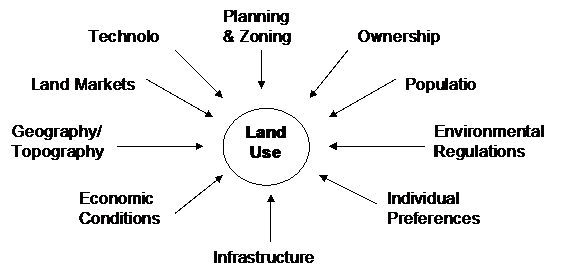
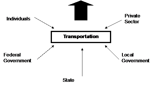
Land development is influenced by a large number of forces
shown in the figure below. Infrastructure, which is comprised of sewer, water,
utilities and transportation play an important role in influencing land use
patterns. Transportation in turn is affected by individuals, private sector,
federal government, state and local governments. As mentioned earlier, the most
significant role that transportation plays in land development is affecting
access to land. Transportation systems have the potential to indirectly affect
land development by either inducing new development or altering the pattern of
development. Even through a transportation improvement may not bring growth to
a region in terms of number of households or square feet of developed area, it
may affect the location pattern of land uses. However, due to the large number
of factors affecting land use patterns, transportation may be considered just a
part of a complicated process of land development.
Transportation’s Role in Land Use
|
|
|
|
|
|
 |
|
|
|
Sewer
Water
Utilities
Transportation
|
|
|
|
 |
Should Urban Sprawl be a Concern?
Most metropolitan communities that
have become the victims of urban sprawl are paying a heaving price through the
increase in congestion, long commutes, loss of natural resource land, vanishing
open spaces, air and water pollution, neighborhood and inner city
deterioration, and the rising cost of public services. In 1950, 70% percent of
the population in metropolitan areas lived in central cities. By 1990, that
situation had reversed, with more than 60% percent living in suburbs (Rusk
1993). Over the past few decades, developed land area and vehicle use increased
at a pace faster than population growth (Federal Highway Administration 1993).
The Transit Cooperative Research
Program (TCRP) sponsored by the Federal Transit Administration published a
report on the “Costs of Sprawl – Revisited” (report 39) in 1988. The following
are a few key points from this report on the positive and negative impacts of
sprawl:
Negative Impacts of Sprawl:
·
Higher infrastructure and public operating
costs: This includes the cost of local and regional roads, water, sewer, school
systems, etc. and was found to be higher in low-density developments than in
compact developments with centralized services.
·
Higher aggregate land costs: The total land
costs associated with sprawl driven development is higher as more land is
consumed then under compact development patterns.
·
Consumes prime agricultural land: Sprawl
consumes prime agricultural land from farming use than more compact forms of
development. This also lowers the productivity of the farmland near sprawl
developments due to the difficulty of conducting efficient farming operations.
·
Lack of community sense: Sprawl driven
developments do not lend themselves easily to the formation of cohesive
communities. The households lack a sense of belonging to the community in such
environments.
·
Worsens pollution: Sprawl worsens the overall
air pollution in a metropolitan area due to the increased number of vehicle
miles traveled. It also lowers water quality by increasing the amount of
impervious surface, thereby increasing runoff and erosion.
·
Encourages deterioration of the inner city:
Sprawl encourages businesses and households to leave the inner city allowing
them to move to the suburbs in search of cheaper land. As a result, the
economic base of the inner city is weakened.
Positive Impacts of Sprawl:
·
Lower housing costs: Sprawl has lower housing
costs because it does not limit the amount of development and land is also
cheaper in the suburban fringes than within the city limits.
·
Supports the American dream of low-density
living: Sprawl encourages the growth of low-density residential neighborhoods,
which are preferred by a large percentage of the population.
·
Enhances personal and public open space: Sprawl
provides more open space directly accessible to the individual households in
the form of larger private yards than may be possible in more compact forms of
development. It promotes the American dream of a big yard and a house set back
from the street.
·
Lower crime rate: Low-density development
patterns have lower crime rates.[i]
How Does Transportation Impact Us?
Transportation touches the lives of
nearly everyone every day. Whether traveling to work, school, or to a favorite
vacation spot, Wisconsin's transportation network will provide the means to get
here. Working for Wisconsin's future
Wisconsin's transportation infrastructure has come a long way in a single
generation. It has developed from a system of two-lane roads and highways,
grass landing strips, wooden piers, and locomotives, to a network of multi-lane
divided highways, airports, modern water ports, efficient transit systems and
rail lines linking the state with markets throughout the world.
For the traveling public, Wisconsin
had 3,733,077 licensed motorists
at the end of 1999 and more than 4.7
million registered vehicles can travel on over 111,500 miles of highways,
roads, and streets. This includes 12,000 miles of state and interstate highways,
and 98,000 miles of locally-owned county, town and municipal routes with 13,300 bridges spanning over
these roadways.
Within the state's communities, 68 public bus and shared-ride taxi systems
connect people with economic opportunities while reducing traffic congestion.
The State Airport System Plan includes 131 public access airports, 9 offering scheduled flights
that carry over 4 million passengers annually. Amtrak transports more than
425,000 people to Chicago, Minneapolis and other points across the country
every year.
For business and industry,
Wisconsin provides efficient and cost-effective transportation alternatives to
get products to market. In addition to its safe and efficient network of
highways for trucks, Wisconsin has 4,500
miles of track and 12 railroads handling 94 million tons of cargo
along with 15 major ports.
And if it has to be there fast, Wisconsin's airports handle 120,000 tons of
cargo annually.
Currently, nearly 12% of all Wisconsin work trips are made by
walking and bicycling. In several cities, almost 20% of trips are
made by these modes. WisDOT has recently partnered with the Bicycle Federation
of Wisconsin to provide the state bicycle map. The Rustic Roads System,
created in 1973, provides bikers, hikers, and motorists an opportunity for
leisurely travel through some of Wisconsin's scenic countryside. To date, 86 rustic roads have been
preserved for purposes of recreational enjoyment covering 461 miles in 49
Wisconsin counties.
Wisconsin Traffic Crash
Facts
 1999 Facts and Figures
·
744
persons were killed in Wisconsin motor vehicle traffic crashes. (36% involved
Alcohol, 27% involved Speed, and 14% involved both Speed and Alcohol).
·
61,577
persons were injured in 41,345 reported injury crashes and 674 fatal crashes.
·
An
average of 2.0 persons were killed every day on Wisconsin highways.
·
The
fatality rate per 100 million miles of travel was 1.31 in 1999, compared to
1.26 in 1998.
·
Of
the 439 drivers who were killed and tested for alcohol concentration, 159
drivers (36%) had an alcohol concentration of .10 or above and were legally
intoxicated.
·
55
pedestrians were killed, compared to 64 in 1998.
·
Of
the 55 pedestrians killed, 9 (16%) had an alcohol concentration of .10 or
above.
·
18
bicyclists were killed, compared to 11 in 1998.
·
65
motorcyclists were killed, the same number as in 1998.
·
39%
of persons killed in passenger cars (for whom belt use was reported) were using
safety restraints.
·
73%
of all motorcyclists killed in crashes (for whom helmet use was reported) were
not wearing helmets.
·
60%
of all crashes occurred on county trunk highways and local roads.
·
The
total number of registered vehicles was 4,713,643 compared to 4,449,217 in 1998
(a 5.9% increase).
·
The
total number of licensed drivers was 3,733,077 compared to 3,709,957 in 1998 (a
0.6% increase).
 A good transportation system is fundamental
to the physical and economic functioning of any community. Spatially, a transportation system is evaluated
on how well people, goods, and services are distributed from one place to
another. In economic terms, a
transportation system can be viewed as to how much traffic volume and access is
available to support local business activity.
Since a majority of residents in the Town of Rushford commute outside
the town for employment opportunities, the current transportation network is
important to town officials and residents. On December 31 of 1998 the WIDOT
reported a total 107,321 licensed drivers in Winnebago County.
A good transportation system is fundamental
to the physical and economic functioning of any community. Spatially, a transportation system is evaluated
on how well people, goods, and services are distributed from one place to
another. In economic terms, a
transportation system can be viewed as to how much traffic volume and access is
available to support local business activity.
Since a majority of residents in the Town of Rushford commute outside
the town for employment opportunities, the current transportation network is
important to town officials and residents. On December 31 of 1998 the WIDOT
reported a total 107,321 licensed drivers in Winnebago County.
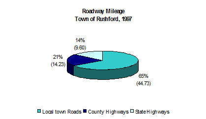
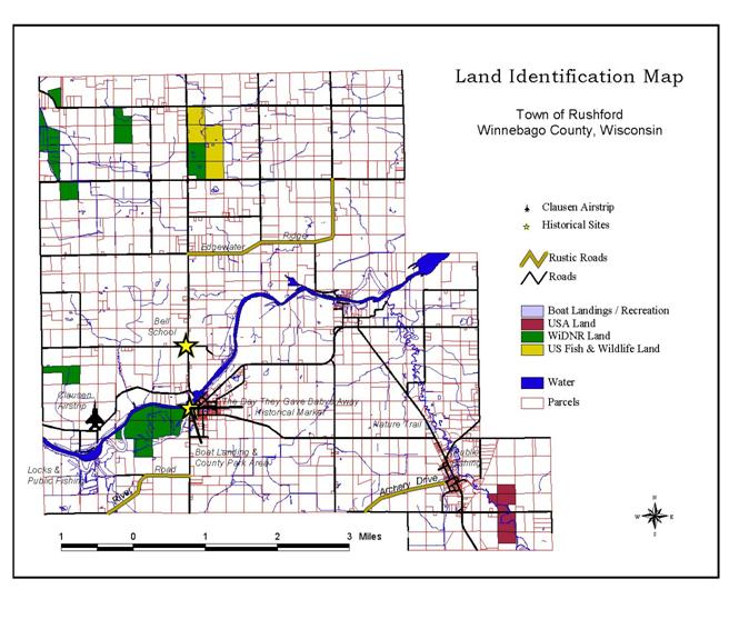
The transportation network in the
Town of Rushford consists of a combination of state, county, and town roads
containing almost 70 miles of roadway.
The distribution of state, county, and local road mileage in the Town of
Rushford can be seen in the accompanying graphic. Town roads dominate the amount of road miles
in Rushford by a significant margin. A
total of 44.73 miles of town roads exist in the Town of Rushford, while 14.23
miles are county highways, and 9.60 miles are state highways. Recognizing the amount of roadway miles
attributed to local roads is especially important because public services such
as general road maintenance and snow removal can present fiscal concerns for
communities such as Rushford.
STATE HIGHWAYS
The primary regional highway
serving the greater Rushford area is Highway 21, which passes through the
northern portion of the town extending west to Redgranite and east to
Oshkosh. A secondary regional highway
also serves the Town of Rushford, which is Highway 116/91. Highway 116/91 passes through the
southeastern tip of Rushford and extends west to Berlin and east to Oshkosh. These two highways are the primary
thoroughfares serving the City of Oshkosh from western and central
Wisconsin. Neither of these highways are
under construction within the Town of Rushford, nor have they been recently
worked on. The Wisconsin Department of
Transportation (WISDOT) does not have any proposals for future construction of
Highways 21 or 116. A review of Wisconsin Department of Transportation 2000
Class II Roadway's determined that the Town of Rushford currently contains none
of these classified roadway's. Proximity to urbanized areas such as Oshkosh,
Appleton, Berlin, and Omro have been viewed as a strength of the current transportation
network which includes state, county, and local roads.
COUNTY HIGHWAYS
The county highways serving the
Town of Rushford are Highways K and E.
Highway K begins at the intersection of Highway 21 near the northern
part of Rushford, passes through the unincorporated Village of Eureka, and
extends east into the City of Oshkosh.
Highway E, on the other hand, enters the Town of Rushford from the
south, passes through Eureka, and extends east into the City of Oshkosh. These two highways intersect in Eureka,
making them the primary roads serving the Town of Rushford. Currently, there is no construction
occurring on either of these roads, nor are there any future proposals for
construction.
LOCAL ROADS
Local roads in the Town of Rushford
consist of an interweaving grid pattern serving residences, town facilities,
county parks, public landings, county highways, state highways, etc. Local roads primarily serve as
"Collectors"
that connect residences, public facilities, parks, county or state highways,
town centers, or major activity centers.
As local roads make up the abundance of road mileage in Rushford, it
becomes very important to consider maintenance, capacity, volume, and access of
these roads, as they pertain to costs and other fiscal capabilities of the Town
of Rushford.
 ROADWAY
CLASSIFICATION
ROADWAY
CLASSIFICATION
The Town of Rushford enjoys a
diverse base of roadway types with a verity of usage within its municipal
boundaries. A Classification of the roadway network for planning purposes
generates four specific roadway types for use in "Master
Thoroughfare" mapping of the roadway system. Roadway classification by
type in the Town of Rushford includes:
1.
STATE HIGHWAYS - State Highways within the Town
of Rushford have limited access with a primary function of inter-town traffic
movement and travel to out of town destinations. Direct access is restricted to
periodic interchanges with ideally no direct access to fronting properties.
2.
PRINCIPAL ARTERIALS - Principal arterial
"primary" streets within the Town of Rushford roadway network are for
the provision of both inter-town and intra-town traffic movement within the
region. The principal arterial provides for efficient traffic flow and a
restricted level of access to fronting properties. Access is limited in order not
to impede the movement of traffic - full access points are spaced no closer
than 1/8 of a mile with full access points at the 1/4 of a mile spacing
typically traffic signal controlled or traffic signed controlled.
3.
MINOR ARTERIAL - Minor arterial "secondary"
streets within the Town of Rushford roadway network are for the purpose of
traffic movement between the neighborhoods and other areas within the township.
While a major function of this arterial is efficient traffic flow, access may
be somewhat restricted to ensure functional purpose. These roadways are
typically traffic signed controlled.
4.
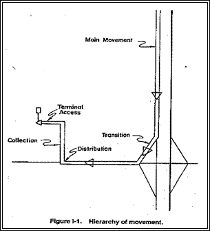 COLLECTOR STREETS - Collector streets within
the Town of Rushford roadway network are for the provision of connecting
residential areas through to adjacent neighborhoods and have continuity between
arterial streets. Collector streets convey traffic out of the neighborhoods to
the arterial streets.
COLLECTOR STREETS - Collector streets within
the Town of Rushford roadway network are for the provision of connecting
residential areas through to adjacent neighborhoods and have continuity between
arterial streets. Collector streets convey traffic out of the neighborhoods to
the arterial streets.
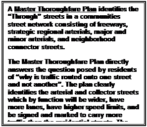
The "Thoroughfare System"
provides the framework of streets and access upon which the Comprehensive Plan
is based. There is a direct relationship between the location of specific sites
within this system and the intensity of land use, which is appropriate for that
area. The Town of Rushford's Master Thoroughfare Plan/Map provides for the safe
and efficient movement of people and goods throughout the community and the
region.
With respect to sound traffic
planning, rule of thumb principals for traffic demand can be evaluated by
considering the following capacity values for passenger cars on a given
roadway:
|
Road Size
|
Average Daily Traffic Capacity
|
|
|
8,000 – 12,000 ADT
|
|
4 Lane
|
16,000 – 24,000 ADT
|
|
6 Lane
|
24,000 – 36,000 ADT
|
ROADWAY USAGE
The Wisconsin Department of Transportation has assumed the role of obtaining
traffic counts along various federal, State, county, and local roads throughout
Wisconsin.
The department usually obtains these
counts every three years, the last being in 1997. Recognizing the amount of traffic that nearby
roads and highways endure on a daily basis is a good indicator regarding
longevity and capacity. Also, traffic
counts are a sign of how timely it is for residents commuting to nearby
employment centers. An analysis of
travel times from the U.S. Census, concluded that most residents travel between
20-29 minutes to their place of work.
Being that Oshkosh is the major employment center in the region, and is
less than 20 miles away from Rushford, there is reason to believe that traffic
volumes are a concern to Rushford residents.
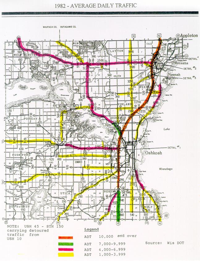
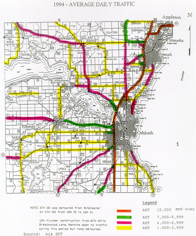
At the County level significant
increases in rural roadway usage have taken place between 1982 and 1994. There
has clearly been a correlating impact to the usage of the roadway system with
respect to the increase in rural residents in the outlying areas of Winnebago
County. These impacts include the need for additional attention by local units
of government in the areas of safety, maintenance and upkeep costs related to
their roadway networks.
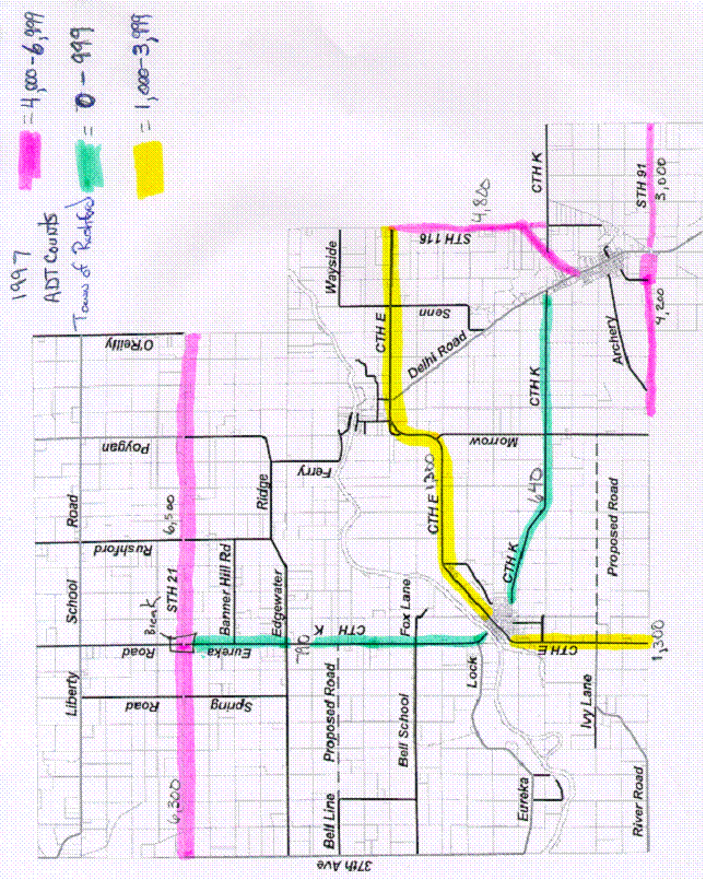
Understanding that traffic volumes have increased significantly on Rushford’s
major arterial and connector roads raises future concern with respect to the
safety, capacity and longevity of the towns roadway system. It is clear from
1991 – 1997 average daily traffic counts that STH 21, CTH K, CTH E, STH 116,
and STH 91 are serving as commuter travel routs of choice. As development
continues to occur the town should undertake measurers to limit new access onto
these major travel corridors in order to ensure safety.
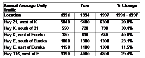
Table 2 shows various traffic
counts taken at select places in the Town of Rushford for the years 1991, 1994,
and 1997. The largest increase observed
was east of Eureka on Highway K, which experienced a 41% increase in average
number of vehicles per day.
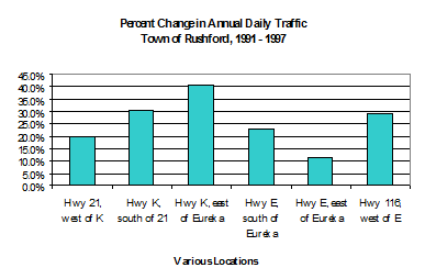
 Other significant
increases occurred south of Highway 21 on County Trunk K (30.4%), and west of
County Trunk E on Highway 116 (29.4%).
These traffic increases could certainly pose a threat to current traffic
patterns and infrastructure conditions in the Town of Rushford. Figure 20 presents the percentage change in
traffic counts at select locations from 1991 to 1997, in graphical form. Past and current trends are apparent.
Other significant
increases occurred south of Highway 21 on County Trunk K (30.4%), and west of
County Trunk E on Highway 116 (29.4%).
These traffic increases could certainly pose a threat to current traffic
patterns and infrastructure conditions in the Town of Rushford. Figure 20 presents the percentage change in
traffic counts at select locations from 1991 to 1997, in graphical form. Past and current trends are apparent.
Given the moderate growth in the
county over recent years, and the growth that Oshkosh has experienced due to
retail business and manufacturing employment opportunities, one can only assume
that this trend will persist in future years.
As a result, additional pressures on existing roads in the Town of
Rushford will likely occur in the future, presenting increased maintenance and
construction costs.
As this growth occurs town
officials will want to be cognoscente of the creation and placement of new
arterial roadways and collector roadways within the community. Maintaining
fluid traffic movement through the community to avoid traffic problems such as
congestion, safety, speed, noise and others is the objective of sound
transportation policy. As a rule of thumb, arterial spacing should follow the
following guidance:
|
Arterial Spacing Principals
|
|
|
Net Residential Units Per Acre Being
Served
|
Location
|
Spacing Distance
|
|
|
Downtowns
|
1/8 mile or less
|
|
6-10 units per acre
|
High Density
|
¼ to ½ mile
|
|
4-6 units per acre
|
Medium Density
|
½ to 1 mile
|
|
2-4 units per acre
|
Low Density
|
2 miles
|
|
|
Semi - rural
|
3 miles
|
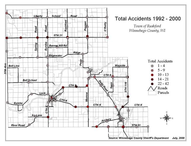
ROADWAY SAFETY
With mounting pressure on the
existing roadway system due to growth and development the Town of Rushford has
experienced its share of safety issues. 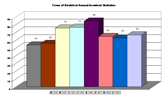
Accidents at many Rushford
intersections have reached levels of concern that are cause for the careful
planning of future loading that could occur through new developments. When intersectional
accident statistics are overlaid on top of the roadway map it can be noted that
a majority of recorded accidents since 1992 have occurred at intersections
involving the State and County highway system within the township.
|
Accident Type
|
1992 Reports
|
1993 Reports
|
!994 Reports
|
1995 Reports
|
1996 Reports
|
1997 Reports
|
1998 Reports
|
1999 Reports
|
2000 Reports
|
Average Through 1999
|
Total Average
|
|
ACCIDENT FATAL
|
1
|
0
|
1
|
0
|
1
|
0
|
0
|
0
|
1
|
0.38
|
0.44
|
|
ACCIDENT HIT & RUN
|
0
|
2
|
2
|
2
|
0
|
3
|
0
|
2
|
0
|
1.38
|
1.22
|
|
ACCIDENT INFORMATION
|
0
|
2
|
0
|
0
|
0
|
0
|
0
|
0
|
0
|
0.25
|
0.22
|
|
ACCIDENT INJURY
|
17
|
6
|
13
|
12
|
14
|
12
|
14
|
12
|
3
|
12.50
|
11.44
|
|
ACCIDENT PROPERTY DAMAGE
|
34
|
44
|
59
|
61
|
70
|
49
|
47
|
53
|
23
|
52.13
|
48.89
|
|
ACCIDENT UNKNOWN
|
0
|
2
|
1
|
2
|
0
|
1
|
2
|
0
|
0
|
1.00
|
0.89
|
As safety issues grow as a concern
within the township, consideration of speed control measurers and traffic
controlling signage and lighting must also be undertaken. According to the
Wisconsin Department of Workforce Development, December 2000, Winnebago County,
“Workforce Profile”[ii]:
“Winnebago County workers are very
mobile. Of the 94,200 residents of the county who have jobs, 40.2% (37,883)
work outside the county. The largest number commute to jobs in Outagamie
County, and that is mostly within the Fox Cities area. Winnebago County
actually gains 2,471 workers in the exchange with Outagamie County. A large
part of this inter-county commute around the Fox Cities relates to jobs in the
paper industry.
Commuters get around Winnebago
County via Highway 41, the main corridor running through the hart of the Fox
Valley. The 441 express way makes the commute for over 2,500 from Calumet
County to Winnebago County much easier than at any time before completion of
that route. It also affords faster access from the Green Bay area.
WINNEBAGO COUNTY COMMUTING PATTERNS
|
|
Commute Into
|
Commute From
|
Net Commute
|
Outagamie County
|
8,942
|
11,413
|
2,471
|
|
Fond du Lac County
|
1,316
|
1,925
|
609
|
|
Waupaca County
|
351
|
931
|
580
|
|
Calumet County
|
375
|
2,622
|
2,247
|
|
Elsewhere
|
2,168
|
3,604
|
1,436
|
|
Total
|
13,092
|
21,238
|
8,146
|
|
|
|
|
|
|
Work in Winnebago County
|
56,317
|
|
|
Commuters to Winnebago County come
from a 16 county area. They travel from Oconto County in the north, Portage
County to the west, Columbia County to the southwest, Door County from the
northeast, Sheboygan, Manitowoc, and Calumet Counties to the east and Fond du
Lac County to the south of the area. Outbound commuters travel to seven other
counties, but most traffic is to Outagamie and Fond du Lac counties. While most
commuters are manufacturing workers, in recent years we have seen an increase
in professional and technical workers expanding their commuting areas from
work. From the Fox Cities to Oshkosh is one of the state’s hottest job growth
areas.” As these commuter patterns continue to expand, further evidence of the
to maintain the safety of Rusford’s roadway system is established.
As a working Philosophy the Town of
Rushford will seek “the least control that provides good operations and a
satisfactory level of safety” when implementing traffic control policies and
stratigies.
Access management
The purpose of access management at the Wisconsin Department
of Transportation is to maintain the operational efficiency and safety of state
highways by controlling the type, number, and location of access points to the
highway system.
Wisconsin's state highway system comprises 12,000 miles of
state and Interstate highways.
·
Access points to the state highway system
automatically increase the potential for crashes by introducing cross traffic
on a free-flowing highway.
·
Access points create operational problems by
slowing the overall traffic flow to allow for slower vehicles that are pulling
off the highway or onto the highway. High volumes of vehicles such as large
trucks or farm machinery can further add to these operational problems.
·
Cost impacts of access are placed on the
individual/organization requesting the access.
In the 2000 State Highway Plan, WisDOT concludes that
current funding levels will not alleviate all the highway system's congestion
problems. With higher capacities and increased congestion, one of the major
tools that will allow our existing highway system to perform with acceptable
efficiency and safety is access management.
WisDOT uses the following tools to manage the highway
system:
·
Driveway permits
·
Trans 233
·
Controlled access projects
Managing access is key to highway safety. More access points
on a roadway means an increased number of crashes.
|
Access points per mile
|
Crash rate per million vehicle miles traveled
|
|
.2
2.0
20.0
|
1.3
2.7
17.2
|
Access management - driveway permits
Driveway permits:
·
Any private access to the state highway system
requires a permit.
·
The permit grants the right to work on state
highway right of way, and the right to access the highway under certain
conditions or restrictions.
·
Driveway permits are not permanent rights and
may be revoked by WisDOT if misuse occurs. Permits may also be revoked if a
highway improvement project requires the elimination of access points to maintain
or increase the free flow of traffic for capacity and safety reasons.
·
Issuing or denying a driveway permit is based on
specific standards such as highway geometry, sight distance, and proximity to
other access points.
The type and maximum size of access is determined by the
intended use of the property. A single-family dwelling may only require a
simple driveway while a commercial property may require more extensive access.
Costs of constructing and maintaining private access points
are borne by the property owner and not by WisDOT.
Determining the type of access required is based on standard
land-use trip generation guidelines.
Access management - Trans 233
Any division or assemblage of lands abutting existing state
highways is subject to review by WisDOT. This includes subdivision plats,
county plats, condominium plats, certified survey maps, plats of survey or a
plain legal description with no survey.
The review ensures:
·
Any access and internal-street system to the
land division serves the maximum amount of landowners, which in turn will limit
future access requests to the state highway.
·
Drainage impacts to state highways are minimized
or controlled.
·
Proper setbacks are used to minimize future
disruptions to the landowner or costs to the public if a highway expansion is
needed.
For more information on Trans 233 visit http://www.dot.state.wi.us/dtid/bhd/trans233.html.
Access management - Controlled access projects
Entire segments of highways can be access controlled through
the completion of controlled access projects. These projects require a public
hearing process to inform all impacted parties and to solicit their input. This
type of project allows WisDOT to then readily manage public and private access
in the future along those segments.
By applying uniform standards such as these, property owners
can be ensured of a fair and equal review.
Effective access management makes our highways safer,
reduces the need for major road expansion by extending the usefulness of
existing highways, and produces a more consistent travel flow. This helps limit
congestion, reduces fuel consumption and improves air quality.
Wisconsin's Rustic Roads
A Positive Step Backward
Creation
The Rustic Roads System in Wisconsin was created by the 1973
State Legislature in an effort to help citizens and local units of government
preserve what remains of Wisconsin's scenic, lightly traveled country roads for
the leisurely enjoyment of bikers, hikers and motorists.
Unique brown and yellow signs mark the routes of all
officially-designated Rustic Roads. These routes provide bikers, hikers, and
motorists with an opportunity to leisurely travel through some of Wisconsin's
scenic countryside.
A small placard beneath the Rustic Roads sign identifies
each Rustic Road by its numerical designation within the total statewide
system. Each Rustic Road is identified by a 1- to 3-digit number assigned by
the Rustic Roads Board. To avoid confusion with the State Trunk Highway
numbering, a letter "R" prefix is used such as R50 or R120. The
Department of Transportation pays the cost of furnishing and installing Rustic
Roads marking signs.
An officially designated Rustic Road shall continue to be
under local control. The county, city, village or town shall have the same
authority over the Rustic Road as it possesses over other highways under its
jurisdiction.
A Rustic Road is eligible for state aids just as any other
public highway.
Program Goals
·
To identify and preserve in a natural and
essentially undisturbed condition certain designated roads having unusual or
outstanding natural or cultural beauty, by virtue of native vegetation or other
natural or man-made features associated with the road.
·
To provide a linear park-like system for
vehicular, bicycle and pedestrian travel for quiet and leisurely enjoyment by
local residents and the general public alike.
·
To maintain and administer these roads to
provide safe public travel, yet preserve the rustic and scenic qualities
through use of appropriate maintenance and design standards, and encouragement
of zoning for land use compatibility, utility regulations and billboard control.
What is a Rustic Road?
To qualify for the Rustic Road program, a road:
·
Should have outstanding natural features along
its borders such as rugged terrain, native vegetation, native wildlife, or
include open areas with agricultural vistas which singly or in combination
uniquely set this road apart from other roads.
·
Should be a lightly traveled local access road,
one which serves the adjacent property owners and those wishing to travel by
auto, bicycle, or hiking for purposes of recreational enjoyment of its rustic
features.
·
Should be one not scheduled nor anticipated for
major improvements which would change its rustic characteristics.
·
Should have, preferably, a minimum length of 2
miles and, where feasible, should provide a completed closure or loop, or
connect to major highways at both ends of the route.
·
A Rustic Road may be dirt, gravel or paved road.
It may be one-way or two-way. It may also have bicycle or hiking paths adjacent
to or incorporated in the roadway area.
- The maximum speed limit on
a Rustic Road has been established by law at 45 mph. A speed limit as low
as 25 mph may be established by the local governing authority.
The Town of Rushford is currently
home to three state designated rustic roads. Eureka Lock Road, Archery and
Edgewater Ridge have each been designated by the program. By being designated
by the rustic roads program, these roads serve the town by protecting its rural
character by the restrictions that have been placed on them. As the town
continues to grow and develop, additional attention should be given to
designating new roadways as rustic roads as a means to preserve rural character
and to continue to provide a safe transportation system throughout the
township.
One of the primary functions of Town Boards is to maintain the
local roadway system. This includes construction, resurfacing and maintenance.
As the number of rural non-farming residents continues to increase throughout
Wisconsin, communities find themselves taking the opportunity to approach
roadway management from a new perspective. With existing residents wanting to
preserve and maintain rural character and new residents placing a greater
emphasis on “scenic quality” the notion of establishing a scenic rural roads
program is gaining favor.
Road management that takes into account the scenic/rural
character of roads in a way that is much like how a tourist would view a
roadway, placing emphasis on more than just road width, line-of-site, and
pavement conditions. To this end it may be beneficial for local officials to
identify “scenic rural roads” and develop “roadside construction/maintenance”
policies to guide roadwork on these roads, as well as other local roads. One
method to accomplish this and to consider which local roads might be
appropriate for submission and designation as rustic roads would be to conduct
the following exercise[iii]:
Scenic Rural Roadway Evaluation Scorecard
Evaluating
entire road Evaluating a segment of
the road
Location of road segment if appropriate ___________________________
Name of Evaluator
______________________________________________
*
Read the criteria statement
in each of the following boxes. Record the appropriate points in the box
provided for each of the criteria that apply to the road or road segment being
evaluated. When done with both the positive and negative evaluation scoring,
total the points given and write that figure in the total box provided. Half
points may be applied to the below features that are not equal to the “norm”
but deserve some recognition, as long as the total points possible per
attribute is not exceeded.
Positive Attributes:
Attribute
|
Point Value
|
Points
Given
|
|
Continuous or intermittent
large trees on one side of the road for less than 100 yards
|
1
|
|
|
Continuous or intermittent large
trees on both sides of the road for less than 100 yards
|
2
|
|
|
Continuous or intermittent
large trees on both sides of the road with canopy over the road for less than
100 yards
|
3
|
|
|
Continuous or intermittent
large trees on one side of the road for more than 100 yards
|
2
|
|
|
Continuous or intermittent
large trees on both sides of the road for more than 100 yards
|
4
|
|
|
Continuous or intermittent
large trees on both sides of the road with canopy over the road for more than
100 yards
|
6
|
|
|
Pond adjacent to the road
|
2
|
|
|
|
1
|
|
|
Bridge on the road
|
1
|
|
|
Stone, covered or historic
bridge on the road
|
3
|
|
|
Stone wall or wooden fence
|
1
|
|
|
Picturesque farmstead or
unusual building
|
2
|
|
|
Historic structure or
archeological site
|
2
|
|
|
Wildlife viewing are from
road (domestic buffalo, elk, etc., or natural deer, turkeys, etc.)
|
2
|
|
|
Agricultural pattern
(orchard, contour plowing, etc.)
|
1
|
|
Attribute
|
Point Value
|
Points
Given
|
|
|
1
|
|
|
Vista of hill on the road
|
2
|
|
|
Vista “variety” (trees,
fields, wetlands, hills, water, etc.) from road
|
2
|
|
|
Hill on road
|
1
|
|
|
Vista variety (trees,
fields, wetlands, hills, water, etc.) from top of hill on road
|
3
|
|
|
Enframed, enclosed or
valley view
|
2
|
|
|
Panoramic or distant view
|
2
|
|
|
Ephemeral effect (sunset,
mist, reflection)
|
2
|
|
|
Seasonal effect (ice
formations, brilliant foliage)
|
2
|
|
|
View of lake or river from
road
|
2
|
|
|
View of waterfall, cliff or
rock outcrop
|
2
|
|
|
View of wetland, bog, or
remnant prairie from road
|
2
|
|
|
Park like area (including
cemeteries) adjacent to road
|
1
|
|
|
Public park adjacent to
road
|
2
|
|
|
View of “specimen tree”
from road
|
1
|
|
|
Hill with limited roadway
visibility (traffic hazard – slow down)
|
2
|
|
|
Curve with limited
visibility (traffic hazard – slow down)
|
2
|
|
|
|
|
|
|
TOTAL POINTS AWARDED
|
|
|
Negative attributes:
Attribute
|
Point Value
|
Points
Given
|
|
Sever/significant erosion
|
|
|
|
View of gravel pit or sand
mining operation
|
|
|
|
Utility line, corridor, or
substation
|
|
|
|
Strip development
|
|
|
|
Incompatible building
(style, material, lot size, non-farm, non-residential)
|
|
|
|
View of junk yard or
landfill
|
|
|
|
Storage tanks
|
|
|
|
Obtrusive signage (size,
too many, flashing)
|
|
|
|
View of unkept buildings
|
|
|
|
Monotony – “same old same
old” landscape
|
|
|
|
|
|
|
|
TOTAL POINTS AWARDED
|
|
|
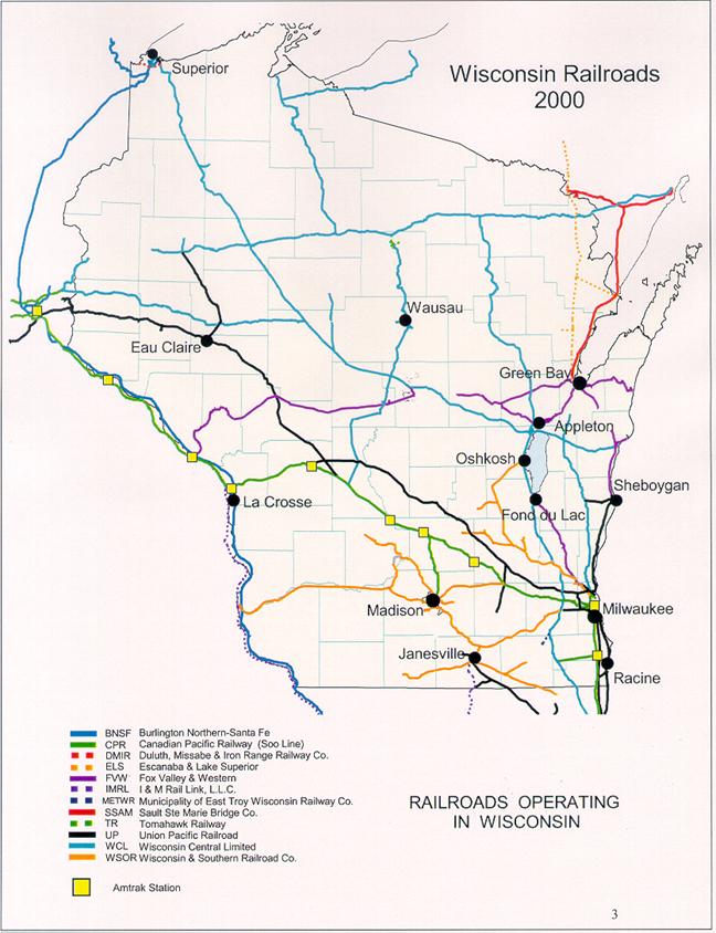
RAIL SERVICE
Rail service is available in the
City of Oshkosh via Wisconsin Central Ltd., and Wisconsin and Southern Railroad
Co. Both rail lines operate with
multiple trains on a daily basis to move products throughout the United States
and Canada. No commuter service is
available.
Significant changes are taking
place with railroads in Wisconsin. Both freight and passenger rail are
constantly evolving to meet changing needs. WisDOT needs to continue rail
planning to enhance the Wisconsin Rail
System and to meet the future transportation needs of the state. With an
increasing population and a steady growth in highway traffic congestion,
freight and passenger rail will become even more vital to the state’s
transportation system.
Freight Rail
Railroads have been part of
Wisconsin since 1847, twenty years after the origin of rail in the United
States. Two factors greatly influenced rail development in Wisconsin. The first
factor is the state’s geographical position between the Great Lakes and the
Northwest. The second factor is the timber resources in the northern half of
the state. The partial depletion of the forest lead to many miles of abandon
railroad in the late 1800’s and early 1900’s. However, the substantial
agricultural and industrial traffic, plus the link to the northwest, kept
railroads an important form of freight transportation in the state.
Wisconsin railroad mileage peaked
in 1920 at 7,327 miles. But from 1920 to 1929, abandonments exceeded new
construction and this pattern continued, and accelerated, for many decades. The
1970’s proved especially difficult for the freight rail industry. Intermodal
competition, economic regulation, the energy crisis, and a recession all
contributed to the distress of the railroad industry. In the early 1980s,
deregulation of the rail industry improved rail’s position to offer competitive
rates for freight service. The number of abandon miles finally slowed
reflecting a growing stability in freight rail. In Wisconsin, larger railroads
abandon or sold large percentages of their lines to newly formed regional railroads.
Also, the state acquired nearly 600 miles of abandon lines for operation by
short line carriers.
Today Wisconsin has 12 railroads
operating on nearly 4,500 miles of track. The state has three class I
Railroads, five regional Railroads, two local Railroads, and two switching
& terminal Railroads. These railroads combine to carry nearly 94,000,000
tons of freight in 1988, more than 1,046,000 carloads. The leading commodity
originating within the state was nonmetallic minerals (over 3,833,000 tons).
The leading commodity to terminate by rail in Wisconsin was coal (nearly
42,000,000 tons).
Passenger Rail
The first rail passenger service in
Wisconsin began in 1851, carrying passengers from Milwaukee to Waukesha. The
wood burning locomotive of the Milwaukee & Mississippi Railroad Company
traveled at speeds of up to thirty mile an hour during the short trek. By 1867,
passenger rail connected Milwaukee with Chicago, as well as the Twin Cities.
From this time until the end of World War I (1918), rail passenger service
continued to prosper and became the predominant mode of travel.
Following World War I, the
automobile became a major competitor of the train. Railroads continued
improving the quality of passenger service into the 1940s, but the number of
miles was declining. Beginning in the 1950s, railroads de-emphasized passenger
trains and rapidly abandon services, to the point that in the late 1960s,
people feared train service would be reduced to just a few routes in the
Northeast.
In 1970, concern over the possible
extinction of passenger trains in many areas of the country prompted Congress
to create Amtrak to operate a national system. Since this time, Amtrak has
experienced a number of staff reorganizations and route changes. Two Amtrak
routes currently run in Wisconsin. The Hiawatha service runs between Milwaukee
and Chicago six times daily. The Empire Builder runs once a day between Chicago
and the Twin Cities, and out to the West Cost. Wisconsin Amtrak rail stations
are found in Sturtevant, Milwaukee, Columbus, Portage, Wisconsin Dells, Tomah
and La Crosse. Amtrak recently announced plans to extend passenger and express
cargo rail service to Fond du Lac and Janesville as part of a comprehensive
effort to preserve and expand existing rail networks.
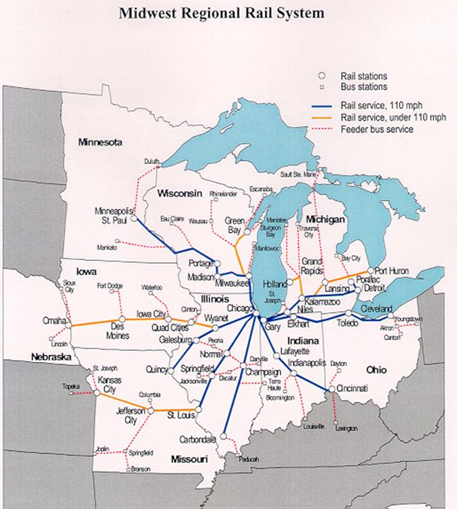
Midwest Regional Rail System
The major plan elements of the
Midwest Regional Rail System (MWRRS) include:
·
Use of 3,000 miles of existing rail
rights-of-way to connect rural, small urban, and major metropolitan areas.
·
Operation of a “hub-and-spoke” passenger rail
system providing through-service in Chicago to locations throughout the
Midwest.
·
Introduction of modern train equipment operating
at speeds up to 110 mph.
·
Provisions of multi-modal connections to improve
system access.
·
Improvement in reliability and on-time
performance.
Within the context of the larger
MWRRI, Wisconsin is involved with the Tri-State II High Speed Rail Study. This
study is nearing completion and evaluates various high-speed options in the
Chicago-Milwaukee-Twin Cities corridor. The analysis has built on the results
of two previous corridor studies: the Tri-State High Speed Rail Study, and the
Chicago-Milwaukee Rail Corridor Study. The Tri-State II Study has looked beyond
the MWRRI and will provide policy makers with information needed to evaluate
and choose among route and technology alternatives in the tri-state area.
As part of the MWRRI, WisDOT began
analysis on the high speed rail corridor between Milwaukee and Madison in
November of 1999. This corridor is part of the first phase of the initiative
and proposed train speeds are up to 110 mph. WisDOT is conducting planning,
engineering and environmental studies along the existing 85 mile long rail
corridor. Service could begin as early as 2003, with six trains daily in each
direction (three of them are proposed to be express service with no stops).
Service (110 mph) between Madison and the Twin Cities could begin in 2005,
while service (79 mph) between Milwaukee and Green Bay is scheduled to begin in
2007. The Milwaukee-Chicago corridor is scheduled for upgrade to 110 mph in
2009, with 10 trains daily in each direction.
AIRPORT SERVICE
Wittman Regional Airport in Oshkosh
is the primary air service for the region.
Wittman Regional offers daily commuter flights to Chicago's O'Hare International
Airport including charter and daily freight service.
Aviation activity in Wisconsin is measured through the use
of information provided by the Federal Aviation Administration (FAA) and
developed from the Wisconsin Department of Transportation (WisD0T) records and
files. Reporting sources include Air Traffic Control Facilities, Flight Service
Stations, Airport Managers and Scheduled Air Carriers.
This report concentrates on activity changes that took place during 2000 as
compared to 1999. The yearly totals for aviation activity at airports with
control towers were taken from the monthly data reports submitted by the FAA
control towers.
The following summarized data is used in developing and measuring Wisconsin
aviation trends.
LANDING FACILITIES
Currently, there are 720 aircraft landing areas known to exist in
Wisconsin. Table 1 summarizes these landing areas.
TABLE 1
Landing Facilities on Record
|
|
1996
|
1997
|
1998
|
1999
|
2000
|
|
Airports open to the public
|
133
|
133
|
132
|
131
|
136
|
|
Publicly owned
|
95
|
95
|
97
|
97
|
98
|
|
Privately owned
|
38
|
38
|
35
|
34
|
38
|
|
Private use airports
|
408
|
395
|
403
|
419
|
426
|
|
Heliport
|
108
|
111
|
115
|
120
|
131
|
|
Seaplane bases
|
28
|
26
|
26
|
27
|
27
|
|
Military/Police fields & helipads
|
7
|
7
|
7
|
7
|
7
|
|
Total
|
684
|
673
|
683
|
704
|
727
|
|
|
|
|
|
|
|
|
Location on the National Plan of
Integrated Airport Systems (NPIAS)
|
88
|
88
|
88
|
88
|
83
|
|
Location on the State Airport System
Plan
|
100
|
100
|
100
|
100
|
100
|
|
Airports with Instrument Approaches
|
75
|
81
|
81
|
83
|
80
|
TABLE 2
Tower Reported Operations by Airport
|
Location/Airport
|
Tower
Hours
|
1996
|
1997
|
1998
|
1999
|
2000
|
% Change
(99-00)
|
|
Milwaukee-Mitchell
|
24 hours
|
200,963
|
212,609
|
219,087
|
221,866
|
221,855
|
0
|
|
Madison-Dane County
|
6 a.-11 p.
|
154,860
|
145,504
|
144,712
|
153,200
|
134,692
|
-13.7
|
|
Oshkosh - Wittman
|
6 a.-10 p.
|
84,027
|
83,260
|
88,809
|
115,500
|
104,393
|
-10.6
|
|
Waukesha - Crites Field
|
6 a. - 9 p
|
68,464
|
87,090
|
89,662
|
96,160
|
90,472
|
-6.3
|
|
Kenosha - Kenosha Regional
|
7 a.-9 p.
|
67,088
|
85,667
|
78,826
|
87,545
|
89,221
|
1.9
|
Statewide total operations for 2000 decreased by 4.87% or
51,487 operations. Only three out of eleven tower airports reported increases
in 2000. Kenosha Regional, Appleton-Outagamie, and Central Wisconsin are the
only airports that reported increases Air carrier operations decreased by 7.93%
and air taxi operations increased by 7.86% statewide. General aviation
operations increased by 6.12% for itinerant traffic and decreased by 7.96% for
local operations.
In all there are basically three types of airports. 1) Large
Municipal/Private airports that are state and federally funded such as Mitchell
County airport in Milwaukee. 2) Small private airports that are for the owner’s
use only, and 3) Small private airports that are used by the owner and only
invited others. In the Town of Rushford one such private airport exists,
Clausen Airstrip.
All airports must be state approved through the issuance of
a certificate for site use in Wisconsin. This process involves the owner
applying to the State DOT. Once an
application is received the state notifies the county and community that an
application has been received and requests comment on opinion and if there are
any local regulations are at issue. It is important to note that the state
certificate does not pre-empt local regulations. As airports are approved the
state forwards information on their location to the Federal Aviation
Administration where they are officially noted on aviation maps.
If a local unit of government wishes, they may regulate
local private airports by ordinance. Typical regulations include:
1. Appropriate
use within the zoning district.
2. Size,
location and number of housing/storage facilities.
3. Hours
of operation.
4. Noise
and pollution.
It is typical of most airports that they start out small and
in rural locations. As time passes and development occurs around these facilities,
inevitably conflict arises. Local governments can act proactively to avoid
these conflicts by planning for growth around existing facilities. In addition,
a regulatory approach can be considered if there is appropriate need.
SNOWMOBILE TRAILS & OPERATIONS
1999 - 2000 Snowmobile Program Report Summary
Wisconsin Law requires that a conservation warden or
law enforcement officer be notified of any snowmobile accident that results in
an injury requiring medical treatment by a physician. In addition, the operator(s)
involved in these "reportable accidents" must file a written report
with the Department of Natural Resources within 10 days of the accident,
insofar as they are capable of doing so.
All fatal snowmobile accidents are investigated by
Conservation Wardens. The 1999-2000 Snowmobile Program Report summary is
compiled from those investigations. There were 38 fatal accidents reported for
the fiscal year 1999-2000 (fiscal year runs from July 1-June 30).
CAUSES
OF THE FATAL ACCIDENTS
The leading cause of death was colliding with an object (tree, bank, car, etc).
The leading contributing factors were, excessive speed and alcohol consumption.
In several cases, speed estimations according to witnesses were reported to be
as high as 100 mph. There were 13 fatal crashes that Conservation Wardens could
directly identify excessive speed as a contributin factor to the death of the
operator/passenger. Of those 13 fatals, 10 of those who died consumed alcohol.
Alcohol was identified as another contributing factor. The law expressly states
a person is under the influence of alcohol once their blood alcohol level
reaches 0.10. Sixty-six percent or 25 of the victims who had known toxicology
reports performed, showed they had consumed some alcohol. There were 8 victims
that were not able to be determined and only 5 victims had no alcohol in their
system at the time of death. Of the total number of victims who had consumed
alcohol, 80% had a blood alcohol reading of 0.10 or higher. With the blood
alcohol readings, 8 were determined to be 0.20 and above.
WHO
WAS INVOLVED
All but 2 of the fatal accident victims were males. The ages of all fatalities
ranged 17-68 years, with the average age 34. Of the 38 fatal accidents, 35 of
the victims were Wisconsin residents while 3 were from surrounding states,
Illinois and Minnesota. The largest percentage of those people killed were age
21-29 (39%). The second largest age group was 30-39 (27%). No one 16 years old
or younger were killed this reporting period. The majority of the victims had
not received formal Snowmobile Safety Training. Of the 38 victims, 30 were
known to have been wearing a helmet, 4 were not and 4 were not known.
WHEN
DO THESE ACCIDENTS OCCUR
A correlation was observed by reviewing fatality statistics for the past five
years. Inferences can be drawn as to the time of day these accidents occur and
day of the week. Not surprising, the majority of the people killed while
snowmobiling, were fatally injured on Friday, Saturday or Sunday. The times
that people were most likely to be involved in a deadly accident is between the
hours of 8:00pm - 3:00am.
|
Sheriff Snowmobile Patrol Citations:
|
Conservation Warden
Snowmobile Citations:
|
|
356
|
TOTAL CITATIONS
|
921
|
TOTAL CITATIONS
|
|
29
|
Operate Snowmobile w/o
Valid Registration (S-1)
|
147
|
Operate Snowmobile w/o
Valid Registration (S-1)
|
|
19
|
Failure or Improper Display
of Registration Number or Decal (S-2)
|
40
|
Failure or Improper Display
of Registration Number or Decal (S-2)
|
|
24
|
Operate Snowmobile w/o Possession
of Valid Certificate (S-3)
|
62
|
Operate Snowmobile w/o
Possession of Valid Certificate (S-3)
|
|
7
|
Failure to Transfer
Registration of Snowmobile (S-4)
|
8
|
Failure to Transfer
Registration of Snowmobile (S-4)
|
|
9
|
Give Permission to Operate
a Snowmobile not Registered (S-5)
|
38
|
Give Permission to Operate
a Snowmobile not Registered (S-5)
|
|
1
|
Transport Uncased Strung
Bow on a Snowmobile
(S-09)
|
0
|
Transport Uncased Strung
Bow on a Snowmobile
(S-09)
|
|
0
|
Shoot From a Snowmobile
(S-10)
|
1
|
Shoot From a Snowmobile (S-10)
|
|
1
|
Operate in Prohibited Area
on Lands Controlled By DNR (S-11)
|
19
|
Operate in Prohibited Area
on Lands Controlled By DNR (S-11)
|
|
78
|
Highway and Roadway
Violations (S-12)
|
112
|
Highway and Roadway
Violations (S-12)
|
|
0
|
Equipment Violation (S-14)
|
6
|
Equipment Violation (S-14)
|
|
8
|
Permitting Operation by
Person Incapable Because of Age, Physical or Mental Disability (S-15)
|
19
|
Permitting Operation by
Person Incapable Because of Age, Physical or Mental Disability (S-15)
|
|
3
|
Failure to Report
Snowmobile Accident (S-16)
|
2
|
Failure to Report
Snowmobile Accident (S-16)
|
|
22
|
Unreasonable Improper or
Careless Operation (S-17)
|
55
|
Unreasonable Improper or
Careless Operation (S-17)
|
|
1
|
Fail to Display Lights when
Required (S-18)
|
0
|
Fail to Display Lights when
Required (S-18)
|
|
25
|
Trespass 'Sec. 350.10(6)
through (13) Wis. Stats.'
(S-19)
|
35
|
Trespass 'Sec. 350.10(6)
through (13) Wis. Stats.'
(S-19)
|
|
1
|
Miscellaneous (S-20)
|
2
|
Miscellaneous (S-20)
|
|
0
|
Dealers Failing to Collect
Fee & Submit Registration Applications (S-12)
|
0
|
Dealers Failing to Collect
Fee & Submit Registration Applications (S-12)
|
|
0
|
Failure to Stop for Law
Enforcement Officer (S-22)
|
1
|
Failure to Stop for Law
Enforcement Officer (S-22)
|
|
1
|
Failure to Render Aid
(S-23)
|
1
|
Failure to Render Aid
(S-23)
|
|
18
|
Operate Snowmobile while
Intoxicated (S-24)
|
25
|
Operate Snowmobile while
Intoxicated (S-24)
|
|
14
|
Operate Snowmobile with
Alcohol Concentration Above .1% (S-25)
|
17
|
Operate Snowmobile with
Alcohol Concentration Above .1% (S-25)
|
|
4
|
Refuse to Take Intoxicated
Snowmobile Test (S-26)
|
3
|
Refuse to Take Intoxicated
Snowmobile Test (S-26)
|
|
1
|
Absolute Sobriety for
Persons Under 19 (S-27)
|
1
|
Absolute Sobriety for
Persons Under 19 (S-27)
|
|
6
|
Operate Snowmobile that
Makes Excessive or Unusual Noise (S-28)
|
153
|
Operate Snowmobile that
Makes Excessive or Unusual Noise (S-28)
|
|
1
|
Operate Snowmobile w/o
Muffler on Engine (S-29)
|
2
|
Operate Snowmobile w/o
Muffler on Engine (S-29)
|
|
1
|
Cause Injury By Intoxicated
Operation of Snowmobile (S-30)
|
0
|
Cause Injury By Intoxicated
Operation of Snowmobile (S-30)
|
|
13
|
Operate w/o Trail Use
Sticker (S-33)
|
127
|
Operate w/o Trail Use
Sticker (S-33)
|
|
0
|
Operate (Manufacture or
Seller) Snowmobile w/o Functioning Muffler (S-34)
|
9
|
Operate (Manufacture or
Seller) Snowmobile w/o Functioning Muffler (S-34)
|
|
69
|
Failure to Comply with
Regulatory Signs (S-35)
|
36
|
Failure to Comply with
Regulatory Signs (S-35)
|
TRAILS
Within the State of Wisconsin there are approximately 22,000
miles of trails. In Winnebago County there are approximately 98 miles of
trails. These trails are categorized as either state funded trails or club
trails. In the Town of Rushford the Eureka Belt Busters maintain two segments of
trail, which pass through the township. While not typically thought of as part
of the transportation system, snowmobile trails provide a seasonal
transportation network that can greatly impact a community.
Wisconsin snowmobilers are proud of the statewide trail
system that ranks among the best in the nation. This trail system would not be
possible without the generosity of the thousands of land owners around the
state as 70% of all trails are on private land. Trails are established through
annual agreements and/or easements granted by these private property owners to
the various snowmobile clubs and county alliances throughout the state.
Snowmobile club members work closely with landowners in the
placement of the trails. They also assist by performing pre-season preparation,
brushing, grading, singing the trails, trail grooming, safety inspections of
the trails and fund raising to support the trail projects. This cooperation
results in the promotion of safe, responsible snowmobiling, and that benefits
everyone. Under Wisconsin State law, Sections 350.19 and 895.52, landowners are
not liable for injury on their property when they have granted permission for
snowmobiling.
 Registration fees and the gas tax on 50
gallons per registered snowmobile help fund nearly 16,000 miles of snowmobile
trails. Specifically, registration fees fund a combination of trail aids, law
enforcement, safety education, registration systems and administration. Gas tax
revenues are dedicated solely to the trails program.
Registration fees and the gas tax on 50
gallons per registered snowmobile help fund nearly 16,000 miles of snowmobile
trails. Specifically, registration fees fund a combination of trail aids, law
enforcement, safety education, registration systems and administration. Gas tax
revenues are dedicated solely to the trails program.
MISCELLANEOUS PROVISIONS FOR SNOWMOBILE
OPERATION
No person shall operate a snowmobile in the following
manner:
·
At a rate of speed that is unreasonable or
improper under the circumstances.
·
No snowmobile may be operated at a speed of
greater than 50 miles per hour during the hours of darkness (1/2 hour after
sunset to ½ hour before sunrise) This restriction applies to all lands. NOTE:
there may be more restrictive speed limits posted by municipalities and within
counties as needed to ensure the safety of riders.
·
Snowmobiles not registered in the State of
Wisconsin must display a Trail Pass to use Wisconsin trails.
·
On the frozen surface of public waters within
100 feet of a person not in or upon a vehicle or within 100 feet of a fishing
shanty unless operated at a speed of 10 miles per hour or less.
·
Between the hours of 10:30 p.m. and 7:00 a.m.
when within 150 feet of a dwelling at a rate of speed exceeding 10 miles per
hour.
·
In any careless way so as to endanger the person
or property of another.
·
On private property of another without the
consent of the owner or lessee. Failure to post private property does not imply
consent for snowmobile use.
·
In any forest nursery, planting area or on
public lands posted or reasonably identified as an area of forest or plant
reproduction when growing stock may be damaged.
·
On a slide, ski or skating area except for the
purpose of serving the area, crossing at places where marked or after stopping
and yielding the right-of-way.
·
On or across a cemetery, burial ground, school
or church property without consent of the owner.
·
On the lands of an operating airport or landing
facility except for personnel in performance of their duties or with consent.
·
On Indian lands without the consent of the
tribal governing body or Indian land owner.
·
On lands owned or under the control of the DNR
and on federal waterfowl production areas, except where their use is authorized
by posted notice or permit.
·
At a speed not to exceed 10 miles per hour and
yield the right-of-way when traveling within 100 feet of a person who is not in
or on a snowmobile.
UNIFORM TRAIL DESIGN STANDARDS
The Department of Natural Resources, in cooperation with the
Department of Transportation, after public hearing, shall promulgate rules to
establish uniform trail and route signs and standards relating to operation
thereon as authorized by law. The authority in charge of the maintenance of the
highway shall place signs of a type approved by the Department of Natural
Resources and the Department of Transportation on highways under its
jurisdiction where authorized snowmobile trails cross.
LOCAL ORDINANCES
Counties, towns, cities and villages may regulate snowmobile
operation on snowmobile trails maintained by or on snowmobile routes designated
by the county, city, town or village.
LOCAL ORDINANCE TO BE FILED
Whenever a town, city or village adopts an ordinance
designating a highway as a snowmobile route, and whenever a county, town, city
or village adopts an ordinance regulating snowmobiles, its clerk shall
immediately send a copy of the ordinance to the Department and to the office of
law enforcement agency of the municipality and county having jurisdiction over
such street or highway.
BOATING & SURFACE WATER TRANSPORTATION
The WiDNR boating program in the Bureau of Law Enforcement
has a wide range of duties and responsibilities. The eight major areas of
responsibilities are:
·
Boating safety education
·
Boating enforcement
·
Boat lien/theft investigation
·
Municipal ordinance review and administration
·
Waterway marker permitting and administration
·
Boat accident investigation, reporting and
administration
·
Designated mooring area review and approval
·
Underwater archaeology protection
Boating Enforcement
State conservation wardens and municipal patrol officers
provide on-the-water enforcement of boating laws. In recent years much emphasis
has been placed on enforcement of boating while intoxicated laws and personal
watercraft enforcement. The United States Coast Guard also provides enforcement
in some areas of the state.
The boating program administers funding to municipal water
safety patrols to reimburse them for up to 75% of their operating expenses. In
1999, municipal patrols received $1,100,00. In order to promote statewide
uniformity and consistency among agencies conducting boating enforcement, the
boating program also conducts yearly training sessions on new laws, policies
and enforcement techniques for all municipal boat patrols.
Municipal Ordinance Review
This program, designed to address local boating concerns and
conditions, assists local municipalities in drafting local boating regulations
tailored to local conditions. Authority for local municipalities to enact local
regulations is found in s. 30.77(3), Wis. Stats. Ordinances are then required
by statute to be submitted to the Department for review. Ordinances are
reviewed for consistency with State and Federal law. Any suggested changes and
comments with regard to the legality of the regulations are provided to the
local municipality. If a municipality enacts an ordinance which the Department
has found to be inconsistent with statutory requirements, the Department may
challenge the ordinance in court.
Waterway Marker Permitting and Administration
This program provides a permitting process for uniform
marking of waters of the state through the placement of aids to navigation.
Conservation wardens inspect individual sites and recommend approval or
disapproval of applications for placement of waterway markers. The boating
program then reviews the application for compliance with state and federal
requirements and either approves or denies the permit. The boating program also
retains a permanent record of all approved buoy applications[iv].
BIKEWAY & PEDSTRIAN MOBILITY ACCOMODATIONS
According to the 1991 “Guide
for the Development of Bicycle Facilities”, the national planning and
design standards published by the American Association of State Highway and
Transportation Officials (AASHTO), “Bicycle facility planning is commonly
thought of as the effort undertaken to develop a separated bikeway system
composed completely of bicycle paths and lanes all interconnected and spaced
closely enough to satisfy all the travel needs of bicyclists. In fact, such
systems can be unnecessarily expensive and do not provide for the vast majority
of bicycle travel. Existing highways, often with relatively inexpensive
improvements, must serve as the base system to provide for the travel needs of
bicyclists. Bicycle paths and lanes can augment this existing system in scenic
corridors or places where access is limited. Thus, bicycle transportation
planning is more then planning for bikeways and is an effort that should
consider many alternatives to provide for safe and efficient travel”.
Not all cyclists are alike – the needs of the experienced
adult rider differ greatly from less skilled, casual bicyclists and children.
The purpose of this section within the Town of Rushford’s Comprehensive Plan is
to identify desirable bicycle facility routes within the Town of Rushford
noting appropriate linkages between route and adjacent communities.
Various environmental factors combine to determine the
suitability of streets and roadways for bicycle travel. However, personal
factors also strongly influence the decision to bike or not to bike on any
given roadway. Cyclists of differing skills will rate the suitability of the
same street differently, based on their perception of safety along the route and
their desire to ride for recreation or transportation purposes. For this
reason, any methodology to rate roadway suitability must begin with an
understanding of the different types of bicyclists.
The concept of a “design cyclist” is used to define three
basic types of bicycle riders who have differing facility preferences and
safety needs.
·
Group A, or advanced bicyclists, include expert
adult riders who operate under most traffic conditions and typically ride on
collector and arterial streets.
·
Group B, or basic bicyclists, are casual or new
adult and teenage riders who are less confident and capable of operating in
traffic without special provisions for bicycles.
·
Group C, or child bicyclists, typically refers
to pre-teen riders who do not yet have a driver’s license and whose roadway use
is limited to residential streets with low motor vehicle speed limits and
volumes.
Due to similarities in riding skills and facilities
preferences, the design bicyclist concept supports combining types B and C so
that there are two basic classes of bicyclists: Group A riders and Group B/C
riders. It is estimated that nationally Group A cyclists represent fewer than
5% of the population, while Group B/C riders comprise the remaining 95%.
Many methodologies have been recently developed to assist in
assessing the suitability of urban streets for bicycle use. The stress level
concept originated in Geelong, Australia and has been further refined to
reflect accepted U.S. roadway engineering practices. The concept builds upon the
idea that bicyclists wish to minimize physical effort in route selection, as
well as mental effort or “stress.” It focuses on three primary factors that
contribute to stressful riding conditions: the amount of traffic, speed at
which the traffic is operating, and the amount of roadway space available for
bicyclists to share with traffic. While other factors such as quality of
pavement surface and aesthetics of adjacent land uses may contribute to the
riding experience, these characteristics are not detrimental to route selection
and are therefore not weighted as such in the stress level evaluation.
Reviewing roadway suitability for bicycle travel in the Town
of Rushford utilized a roadway analysis of the following:
|
Stress
Level Rating
|
Volume
Of cars using right lane per hour at peak travel
time
|
Width
Of right lane, including bike lane/shoulder
|
Speed
At which motor vehicles are traveling
|
Stress Level Interpretations
Based upon the combine volume, width and speed
characteristics
|
|
1
|
[50 vph
|
á15 ft
|
[25 mph
|
Very low – streets are reasonably safe for all types of
bicyclists.
|
|
2
|
150 vph
|
14 ft
|
30 mph
|
Low – Streets can accommodate adult Group A and Group B
bicyclists: may need to be altered or have compensating factors to
accommodate younger Group C bicyclists.
|
|
3
|
250 vph
|
13 ft
|
35 mph
|
Moderate – Streets can accommodate experienced Group A
bicyclists: may need to be altered or have compensating factors to
accommodate Group B bicyclists: not recommended for children.
|
|
4
|
350 vph
|
12 ft
|
40 mph
|
High – Streets can accommodate the most experienced
cyclists: may need to be altered or have compensating factors to accommodate
other adult riders: not recommended for Group C child bicyclists.
|
|
5
|
450 vph
|
11 ft
|
45 mph
|
Very High – Streets may need compensating factors to accommodate
even the most experienced bicyclists.
|
The map that follows depicts the stress level ratings for
evaluated roadways within the Town of Rushford. In addition, notation has been
made of county and state plans and recommendations.
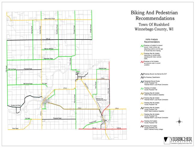
GOALS OBJECTIVE &
POLICIES
Goal #1 – To
classify roads in the Town of Rushford.
Objective -
Maintain an accurate and up to date Master Thoroughfare Road Plan.
Goal #2 – To
promote corridor planning and preservation.
Objective -
Minimize development in areas which are likely to be required to meet
transportation needs in the future.
Goal #3 – Work
with neighboring communities to solve mutual problems.
Objective – Work
with neighboring communities to solve problems along major arterials so that
the entire corridor may be addressed, not just up to the border.
Goal #4 – Create
setbacks for future road expansions on arterials.
Objective – Ask
developers and individuals to dedicate a portion of their land for necessary
transportation improvements.
Goal #5 – Map
future roads and corridors.
Objective –
Official mapping of future rights of way can be used to inform the public and
prevent development in locations of future facilities.
Goal #6 –
Preserve safety and mobility with access management tools.
Objective – The
site design of new developments should be compatible with efficient movement of
traffic, on to and off of public roadways and, at the same time are conducive
to pedestrian movements, bicycle traffic and transit use. All new developments
should be required to go through a site design/development review process.
Goal #7 –
Regulate the location, spacing and design of driveways.
Objective –
Wisconsin statutes give all levels of government the authority to require a
permit for the construction of a private driveway onto a public road. The Town
of Rushford shall amend its existing ordinance with appropriate standards to
initiate its permitting process within the township according to the policies,
goals and objectives as set forth by this Comprehensive Plan.
Goal #8 –
Increase minimum lot frontages along arterials and collectors.
Objective –
Minimum lot frontages along arterials and collectors should be increased to
allow for greater spacing between driveways.
Goal #9 – Create
subdivision regulations and site plan review standards.
Objective – Create
and implement these regulations so that proper street layout in relation to
existing or planned roadways occurs; adequate space for emergency access and
utilities is provided; adequate water, drainage, and sanitary sewer facilities
are provided; and appropriate site design is created. The administrative review
and evaluation procedure for processing conceptual, perliminary and final plats
shall include on the plat; design principals and standards for lots, blocks,
streets, public places, pedestrian ways, and utilities; required improvements,
including streets, sidewalks, water sewer and curbs and gutter; and financing
and maintenance responsibilities. These regulations will help justify decisions
made and help developers have a clear idea of what is expected in the
community.
Goal #10 –
Promote connected developments.
Objective –
Require “stubs” in developments so that future developments may be connected to
the roadway network.
Objective – Limit
the use, length and number of lots for cul de sacs and dead ends.
Objective –
Require pedestrian and bicycle paths at end of cul de sacs which connect to
activity centers.
Goal #11 – Avoid
flag lots on arterial streets and collectors to ensure appropriate spacing
between driveways.
Goal #12 –
Provide residential properties access within developments, not on arterials.
Goal #13 –
Require review of all minor replats. Ensure that arterials and collectors are
not lined with driveways from small lots by reviewing all minor splits.
Goal #14 –
Monitor airstrip use within the township, taking action with appropriate
regulation only if warranted.
Goal #15 – Work
with WiDNR wardens and the Winnebago County safety patrol to enforce speed
limits for safety along the Fox River.
Goal #16 –
Consider the need to map official snowmobile routes within the township and
work with local clubs to ensure safety.
[i]
Transportation And Land Use Primer. By Smitha Vijayan, UWM Center for Urban
Transportation Studies.
[ii]
Winnebago County Workforce Profile, Wisconsin Department of Workforce Development,
Division of Workforce Excellence, Bureau of Labor Market Information and
Customer Services, December 2000, DWEI – 10663-P (R. 12/2000).
[iii]
Developed by Brad Bauer, Vierbicher Associates, Inc. ãVierbicher Associates,
Inc., 2001.
[iv]
WiDNR 1999 Boating Program Report, PUBL-LE-314 (06/00 REV).