7.1
UTILITIES & COMMUNITY
FACILITIES ELEMENT
Statutory definition:
Utilities
and community facilities element. A compilation of objectives, policies, goals, maps and
programs to guide the future development of utilities and community facilities
in the local governmental unit such as sanitary sewer service, storm water
management, water supply, solid waste disposal, on–site wastewater treatment
technologies, recycling facilities, parks, telecommunications facilities,
power–generating plants and transmission lines, cemeteries, health care
facilities, child care facilities and other public facilities, such as police,
fire and rescue facilities, libraries, schools and other governmental
facilities. The element shall describe the location, use and capacity of existing
public utilities and community facilities that serve the local governmental
unit, shall include an approximate timetable that forecasts the need in the
local governmental unit to expand or rehabilitate existing utilities and
facilities or to create new utilities and facilities and shall assess future
needs for government services in the local governmental unit that are related
to such utilities and facilities.
Inventory
& Status:
The Town of Rushford is a
typical rural Wisconsin township operating minimal public utilities and
community facilities at this time.
Sewer & Water;
Currently no sewer or water
public utility systems are under town or utility district operation within the
township. Businesses and residences operate solely on private onsite systems at
this time. Some historic discussion has occurred over the possible
establishment of a water & wastewater utility for servicing the Eureka area
within the township.
While local desire to
undertake the establishment of such a district has yet to reach any consensus
based conclusion, future development of the area may spur interest in
reconsideration of the possibility of a district. In addition to the areas
potential growth and its related impacts, it can be noted that several failing
onsite systems currently exist. When taken into account these failing systems
pose additional difficulty in that most exist on lots of insufficient size for
the construction of a new system.
Schools:
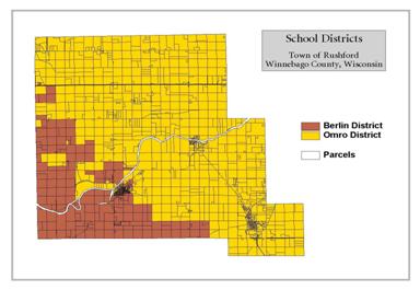 The Town of Rushford
is overlain by two school district boundaries. The Omro
School District and the Berlin School District. Current estimates
indicate that the Omro School District draws 256 children from the Town of
Rushford into its classrooms and the Berlin School District draws 86 children.
Both draw significant portions of their student population from residencies
within the Town of Rushford. As the town continues to grow and develop
conscious coordination with each school district will need to be undertaken in
order to ensure that capacity is not exceeded or avoidable financial stress
occurs.
The Town of Rushford
is overlain by two school district boundaries. The Omro
School District and the Berlin School District. Current estimates
indicate that the Omro School District draws 256 children from the Town of
Rushford into its classrooms and the Berlin School District draws 86 children.
Both draw significant portions of their student population from residencies
within the Town of Rushford. As the town continues to grow and develop
conscious coordination with each school district will need to be undertaken in
order to ensure that capacity is not exceeded or avoidable financial stress
occurs.
Parks,
Recreation & Open Space
 In the Town of Rushford a significant
amount of acreage is in public ownership. Spread amongst four principal owners,
this land base consumes 980.23 acres within the town. While this acreage
benefits local residents in what it provides, it also limits the ability of new
growth to occur.
In the Town of Rushford a significant
amount of acreage is in public ownership. Spread amongst four principal owners,
this land base consumes 980.23 acres within the town. While this acreage
benefits local residents in what it provides, it also limits the ability of new
growth to occur.
![]()
Because Winnebago County is located in what was formerly one of the best regions of the state for duck and pheasant production, the Department of Natural Resources initiated the Glacial Habitat Restoration Area project in the southwestern part of the county. This project is designed to restore wetlands and grasslands on private lands and public lands to benefit mallards, blue-winged teal, pheasants, and grassland songbirds.
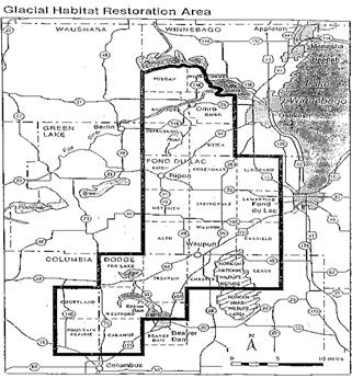
“The goals of the program are to restore 10% of
available upland to permanent grassland, and to restore 10% of the drained
wetlands. The department is purchasing land and perpetual conservation
easements from landowners within the GHRA in order to meet habitat goals.
Department ownership in any town will not exceed 10% of the total land.
The properties the DNR currently owns are managed
primarily for grassland birds and other native wildlife. On properties the
department manages, croplands are gradually converted to native prairie, and
wetland drainage’s are disabled, creating a mix of wetlands and grasslands
crucial to wildlife. An integral part of grassland management is prescribed
burning. Grasslands evolved with fire and the department periodically burns
(every 3-5 years) these properties to enhance and maintain the biological
integrity of the land.
The fee-title properties are open to hunting,
trapping, hiking and other non-motorized nature based recreation”.[i]
Also with this part of the county, and the Town of
Rushford, lies the Thull tract of the Uihlein Waterfowl Production Area
administered by the U.S. Fish and Wildlife service’s National Wildlife Refuge
System. In southeastern Wisconsin the Leopold Wetland Management District is
responsible for management of the WPA’s.
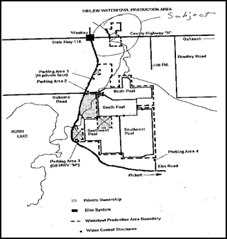 Long term goals for
the Fish & Wildlife Service is to continue acquiring land from willing
sellers as it becomes available to “round out” or join together the tracts
already under ownership. Management objectives for the Thull tract of the
Uihlein WPA are to:
Long term goals for
the Fish & Wildlife Service is to continue acquiring land from willing
sellers as it becomes available to “round out” or join together the tracts
already under ownership. Management objectives for the Thull tract of the
Uihlein WPA are to:
1. Help
assure the continued availability of habitat capable of supporting migratory
bird populations at desired levels.
2. Demonstrate
optimizing the practice of wildlife and wildlands management.
3. Expanding
the understanding and appreciation of wildlife, wildlands ecology and man’s
role in his environment.
4. Develop
optimum levels of the kinds, range, amount and quality of wildlife and
wildlands-oriented recreation desired.
5. Help
assure the survival of a natural state of each of this areas plant and animal
species.
6. Optimize
the abundance and diversity of native wildlife on each WPA compatible with
carrying capacity and other constraints.
7. Restore
and maintain the native prairie/savanna portion of this tract through the use
of management tools such as fire, cutting, herbicide treatment, etc.
Possibility of removing and re-seeding non-local genotype nesting field
adjacent to prairie/savanna remnant to ensure genetic integrity of native
prairie and savanna remnant.
8. Maintain
native seeded grass/forb fields through the use of fire.
9. Maintain
seeded cool-season (CRP) fields to provide a diversity of habitats.
10. Improve
the remaining oak savanna/hard wood stands through the use of fire.
11. Remove
and treat Boxelder stands.
12. Maintain
grassland buffer adjacent to Waukau creek for water quality improvement
purposes.
The Winnebago County Parks system operates two
facilities within the Town of Rushford. These facilities include a special
purpose facility and a preservation/conservation area[ii].
·
The Eureka Boat Landing – Description; During the spring Walleye and Bass runs, this small launch
area is used to capacity. Three boat ramps with adjacent boat tie-ups provide
barely adequate space for the numerous fishermen using the site. A well,
toilets and a picnic shelter compliment the other facilities. This park of 5.7
acres is located on the Fox River in Eureka off of county road K.
Projects for this area
include;
1. Maintain
river frontage riprap on an as-needed basis.
2. Accelerate
the existing landscaping program.
3. Improve
parking areas by seal coating.
4. Provide
pathways for pedestrians and wheelchairs to shoreline wharf area.
·
Waukau Creek Nature preserve – Description;
This beautiful site is located north of Waukau on Delhi road off county road K.
Sixty four acres in size, the preserve contains the only flowing stream or
brook in Winnebago County (Rush Creek). The densely wooded, steep walled
ravines slope into a broad creek floodplain. Wildflowers abound throughout the
entire park and color schemes and variety change with the season. Self-guiding
nature trails with interpretive signs and hiking trails allow the user to
explore and learn about this unique area.
In 1992 the County acquired an additional 28 acres of property just north of Waukau off Highway 116. This property is about ½ mile away from the nature preserve and Rush Creek serves as the connection between them. This land has been owned by the Wisconsin Department of Natural Resources and contains a rough fish holding pond and water regulation devices to control the water level in the pond and divert the flow of the creek. The topography of this site is similar to the main preserve, with wooded steep walled ravines, however, the floodplain area is considerably smaller and much of it is taken up by the pond.
The following
improvements/projects have been identified for the next five-year period;
Property off Delhi Road
1. Acquire
adjoining property to expand this park area.
2. Maintain
the existing nature and hiking trails in a quality condition and construct new
trails as land acquisition allows.
3. Expand,
where feasible, the educational capacities of the trail system and nature
preserve.
4. Investigate
obtaining either the property or an easement to connect the two parcels of
land. Ideally the connecting link would follow the creek and be a hiking trail.
5. Complete
bridge building projects to improve access to the east side of the property.
6. Upgrade
all signing on the property.
Property off Highway 116
1. Repair
approaches to the bridges so as to make them wheelchair accessible.
2. Upgrade
the trail that goes around the holding pond with crushed limestone screenings
so as to make the trail wheelchair accessible.
3. Repair
any gates and weirs on the property to keep them functioning properly.
4. Seal
coat the parking lot.
5. Construct
one picnic shelter and provide necessary site amenities.
6. Control
brush around holding pond and in select areas on creek banks so as to provide
access to the water by building fishing platforms for park users.
7. Take
necessary measures to control erosion of the holding pond banks, especially
near the bridges.
8. Work
with WIDNR staff to learn operation of gates and weirs on the property, and
develop a plan for shore fishing opportunities in the holding pond (to include
stocking fish if feasible).
National Recreation and Park Association (NRPA)
guideline classifications for local parks and recreation planning[iii]
classify Rushford’s park and open space amenities in the following fashion.
NRPA - Parks, Open Space, and Pathways Classification |
|||
Classifications |
General Description |
Location Criteria |
Site Criteria |
|
Natural Resource Areas |
Lands set aside for preservation of significant
natural resources, remnant landscapes, open space, and visual
aesthetics/buffering. |
Resource availability and opportunity |
Variable |
|
Special Use |
Covers a broad range of parks and recreation
facilities oriented towards single purpose use. |
Variable – dependent on specific use |
Variable |
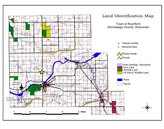
In
addition to lands in public ownership, the Town of Rushford contains two
historical sites, three rustic roads, one private airstrip, two public fishing
locations, a boat landing and a nature trail. These amenities also contribute
to local resident’s quality of life while adding potential economic opportunity
to the town as they are developed and marketed. They communicate to all who
enjoy them a message of what the community values and a sense of its history.
Town
Government Facilities
The
Town of Rushford Town Hall resides in the crossroads community of Eureka. The
building is somewhat antiquated but sufficient for the conducting of town
business and affairs. Recent improvements include the installation of new
carpeting. While the facility currently lacks indoor plumbing, no major future
improvements are planned at this time.
The
Town of Rushford is also a member of the Village of Omro, Town of Rushford and
Town of Omro Fire District. Plans are currently being discussed for the siting
and construction of a new fire station facility.
GOALS, OBJECTIVES & POLICIES
Goal
#1
The Town of Rushford will
continue to monitor the need for public utility services throughout the
township.
Objective: If
needed, the town will facilitate discussions about the need for public utility
services for either the greater Eureka or greater Waukau areas.
Goal
#2
The Town of Rushford will
ensure adequate parks, recreation and open spaces for its residents.
Objective:
The town will work cooperatively with WiDNR, and the USF&W agencies in the
management of their properties within the township.
Objective:
The Town will work cooperatively with Winnebago County to manage county parks
and recreation facilities within the township.
Objective:
The town will supplement the Wuakau Creek Nature Preserve by placing into
conservation the Rush Creek bed corridor for the area between the counties two
current holdings and up stream to the USF&W Uihlein WPA property holding.
Objective:
The town will protect and ensure additional future open space by considering
the adoption of a conservation subdivision ordinance, implementing a site plan
review program as part of its land division ordinance and considering mandatory
open space percentages for all new subdivision developments.
Goal
#3
The town of Rushford will
continue to provide adequate facilities for the purpose of gathering to conduct
public business. The town will also ensure that adequate facilities for police
and fire protection exist.
Objective:
The town will continue to manage its Town Hall facility to ensure that it meets
the needs of local residents.
Objective:
The town will work cooperatively with its fire district partners to ensure
adequate fire protection, equipment and facilities exist.
Objective:
The town will continue to work cooperatively with the Winnebago County Sheriffs
Department to ensure the safety and protection of its citizens.