Creating a
built environment that meets with
local social values.
8.1 Land
Use
Among the most effective tools a community possesses
to influence its future environment and quality of life is the ability to
control and direct future growth patterns through its zoning and development
ordinances, and its provision of infrastructure to serve newly developing
areas. Through its zoning powers, the
Town of Rushford has an opportunity to guide future growth in a manner that
enhances its residents’ quality of life and fits within its future vision. Misguided use of these tools, however, can
lead to undesired results in terms of land use conflicts, inefficient service
delivery, and a decreased quality of life, among other potential problems. The foundation for sound decision making and
implementation of these tools is a clear land use plan based upon sound
planning principles and the community’s vision for its future.
This land use plan is intended to illustrate this
vision and guide the future growth and development of the Town over the next 20
years and beyond. It will serve as a
guide for the Town Plan Commission and Town Board when making land use, zoning,
and infrastructure related decisions. It
will also provide direction for private sector property owners and potential
developers when making decisions about the future of their properties within
the Town of Rushford.
The Town must study the suitability of land in order
to effectively plan for efficient and environmentally sound growth. Therefore, the land use analysis and future
land use plan is not limited to properties within the Town’s existing developed
areas, but looks beyond to consider areas that might be appropriate for growth
over the next 20 years and beyond. In
order to ensure that sufficient growth areas are maintained to accommodate a
reasonable level of development expansion, strategies must also be implemented
to control the development of residential and commercial growth immediately
surrounding key transportation corridors and environmentally sensitive
areas. At the same time, the Town of
Rushford has expressed concerns about the impacts of urban development on rural
properties, primarily having to do with storm water run off onto all
properties.
The relationship between the Land Use Element and
other plan elements is extremely important, and coordinating this information
is essential in developing an effective Comprehensive Plan that is useful to
the Town and its constituents. All of the eight other elements of this plan
should influence the decision making process in the approval considerations of
new development proposals. As time progresses this plan must be updated and
coordinated with its balance in order to ensure that local development
preferences are maintained. By statutory law this Comprehensive Plan must be
updated at least once every ten years.
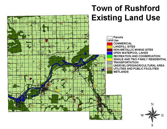
Existing Land
Use
Existing development within the Town appears to have
occurred in a fairly traditional fashion to this point. With the exception of three residential
clusters, in the cross-roads communities of Eureka, Wuakau and the residential
concentration of Island Ave & Ferry Lane, new residential development has
generally occurred on roadside parcels that have been split off of longtime
farming operations. While relatively little “leap frog” development has
occurred some concerns exist. As growth and economic changes in the “Fox
Valley” region have occurred, traditional agricultural lands are slowly being
divided into rural residential and “hobby farm” uses. A map illustrating the
existing land use pattern within the Town illustrates how this pattern of
development has contributed to slowly lining its roadways with residential
uses. As these uses have become more common the local sense
of place and rural character have suffered significant impact via visual
aesthetics.
Existing
Land Uses and Acreage in the Town of Rushford
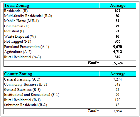
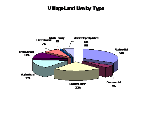
Residential:
Residential development within the Town has predominantly consisted of detached
single-family homes of varying lot sizes.
The current Town zoning ordinance contains a total of two residential
zones, the first of which is exclusively a single-family zone, the second of
which allows for single family uses as well as a multi-family residential
uses. The R-1 Single-Family Residential
District contains a minimum lot area requirement of 40,000 square feet, and
minimum lot frontage requirement of 200 feet. The R-2 Multi-Family Residential
District permits lots of 40,000 square feet with 200 feet of minimum frontage.
The distinction between these two zones is very
important to consider and has potential implications for the Town in the future
as the State’s Smart Growth Dividend Aid Program is finalized and
implemented. The Dividend Aid Program is
scheduled to be implemented in 2005, and is structured such that communities
that have adopted a smart growth plan and meet specified criteria earn “points”
which are to be considered in the allocation of State funds. Whether this means that a new funding source
will be established or this will involve the reallocation of existing funds has
not yet been determined. The two
criteria that have been established thus far to earn these points include the
creation of lots less than ¼ acre in area, and the sale of new homes at less
than 80% of the median housing costs for the County within which a community is
located. Given these parameters, the
Town recognizes the possibility of establishing a sanitary district in the
surrounding areas of Eureka and Waukau. These services could then allow for the
reduction of the minimum lot size requirement within the R-1 zone to 10,000
square feet or less. A second consideration would be to make broader use of the
R-2 zone to provide opportunities for development that can earn Smart Growth
“points”.
Duplex and multi-family housing is present in a few
scattered areas within the Town, but makes up a relatively small portion of the
overall housing stock. The need for
additional senior housing was discussed at the public land use workshop, as
well. As the Housing plan element was
discussed and developed, many issues regarding housing types, lot sizes,
affordability, and specific housing needs were documented and prioritized. This
element should be referenced for these details. With the changing nature of our
society, communities are now faced with meeting the housing needs of a much
more diverse spectrum of family types.
Single-parent households, empty nesters, and childless professionals,
demanding alternatives to the large-lot, detached single-family home and its
associated maintenance, are changing the dynamics of today’s housing
market. This Land Use Plan provides
opportunities for the development of a diverse set of housing types in new
neighborhoods in order to accommodate all family types and families of varying
incomes.
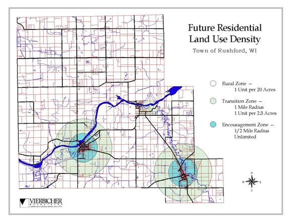
It does this through its provision of a three level
density standard for the siting of residential dwellings. These three zones are
1) the rural zone which will allow for a total density of one unit per 20
acres, 2) the transition zone which will allow for a total density of one unit
per 2.5 acres, and 3) the encouragement zone which will allow for development
to occur up to the carrying capacity of the site limitations. These density
zones are based on the land under ownership as shown in the 2001 Winnebago
County Plat book in order to determine how many units each property owner is
eligible to construct from the date of adoption of this plan forward. Property
owners with large acreage’s will be allowed to develop rural subdivisions but
only if they utilize a cluster or conservation design subdivision technique.
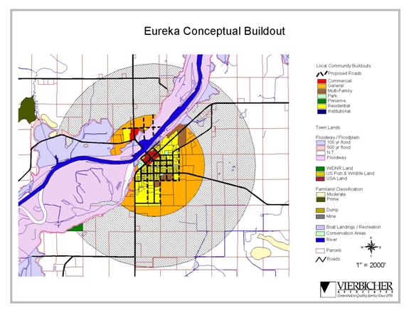
Commercial: Current commercial development is focused in
the downtown areas of the cross-roads communities of Eureka and Waukau. With the exception of the general store shop
and several independent “garage” type businesses, the commercial businesses in
the Town are each part of a business cluster along the main street corridors of
Eureka and Waukau. These locations are highly suitable and highly visible in
the town. Major transportation roadways bisect each of these communities making
the existing businesses uses of these properties appropriate for continued use
in this fashion and possible expansion in the future.
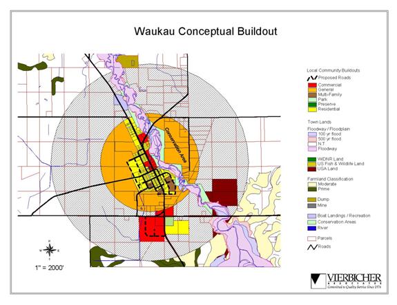
Another potential opportunity for expanding commercial
services in the Wuakau area involves the newly improved Hwy 91/116, County M
intersection site. With the lands abutting the North East and North West
corners of the intersection already offering some commercial use, and the lands
abutting the south East corner developing into a residential subdivision,
opportunity to develop the South West corner into a major commercial area
exists. If available, the site offers a good opportunity to invigorate economic
activity in the downtown area with new development and an expanded array of
commercial services for Town residents.
Agricultural
lands: Agriculture is the predominant land use in the town.
The current town zoning ordinance divides agricultural uses into three
distinctive zones. A-1 “Farmland Preservation District” accommodates the
designated uses of lands under the Wisconsin Farmland Preservation Act found in
Chapter 91 of the Wisconsin State Statutes. Farm dwellings within the district
must have a minimum of 40,000 square feet in area and a minimum of 200 feet of
frontage. The intent of this district is to provide for the strict preservation
and protection of farmlands allowing owners of parcels within this district
eligibility for participation in the states farmland preservation program. The
A-2 Agricultural District allows for all uses customarily incidental to general
farming activities. District standards require a minimum of 40,000 square feet
in area and 200 feet of frontage. It purpose is to conserve good farming areas
and compatible or private uses, and to prevent the uneconomic and uncontrolled
spread of residential development outside the available residential districts
which might result in excessive cost to the township for premature provision of
essential public improvements and services such as sewer, water and utilities.
The A-3 Rural Residential District is intended to
provide a living area in combination with small scale farming activities along
with residential growth. The district is limited in acreage to those parcels of
five acres or less. Area regulations include a needed minimum of 43,000 square
feet and 200 feet of frontage if no public sewer is available.
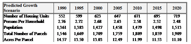
Projections/Expectations
As noted within the Community Profile Report, a peak
in the number of new lots created within the Town in the early 1980s led to
increases in the number of new housing units constructed in the following
years. Since then, however, the number
of newly created lots per year has slowed significantly. While the total number
of new lots has slowed in historic terms, the creation of new lots continues at
a steady pace today.
Developing population projections for small
communities like the Town of Rushford is difficult due to the major influence
that individual events and occurrences can have on the community, such as the
addition or loss of a major employer or changes in elected officials and their
attitudes toward growth. As new
development is platted and comes on the market, it is anticipated that the Town
will experience a steady rate of growth, fueled by the area’s proximity to growing
urban centers such as Oshkosh, and its good access to the regional
transportation system.
A summery of local historical performance combine with
census data predicts that the Town of Rushford will see the following impacts
over the next twenty years.
By adopting this Comprehensive Plan and formulating a
vision for its future, the Town will be in a better position to respond to
future growth pressures if and when they occur.
Physical ANALYSIS
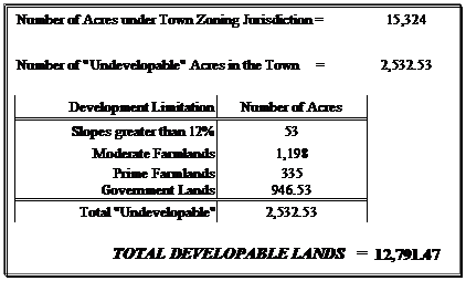
In
addition to the potential impacts of demographic and socio-economic
projections the
Town of Rushford is seeking to preserve a verity of natural and physical
features which it values and/or recognizes places limitations on the potential
for development. An analysis of these features, which include
1. prime farmland 2. Slopes
in excess of 12 & ½%, 3. wetlands &
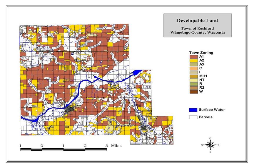
flood plain 4. Governmental lands, found that 12,791.47 acres remain for
potential development under the town’s zoning jurisdiction.